The First Street
Foundation (FS) model shows an increase in flood risk across Rhode Island.
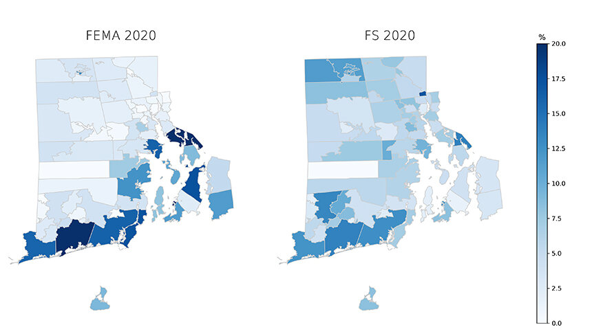
Flooding risks are by zip code. (Roger Warburton/ecoRI News)
Many people who live
inland believe that the risks of flooding from hurricanes, sea-level rise, and
coastal storms don’t apply to them. Surely, they only impact shoreline
properties?
Those assumptions are
incorrect.
A new report by the First Street Foundation analyzes the flood risks of every
building in the United States. One of the most surprising findings is that
there is a much higher risk of inland flooding than previously believed.
The image above
illustrates the significant increase in inland flooding risk. The current risk
for a substantial flood is defined as a 0.4-inch inundation with a 1 percent
annual risk.
Flood risk is
traditionally analyzed using the Flood Insurance
Rate Map (FIRM) published by the
Federal Emergency Management Agency (FEMA). In Rhode Island, FEMA maps identify
some 23,900 properties as having substantial flood risk (the left map in image
above).
In comparison, the First
Street Foundation flood model identifies an additional 9,000 properties as
facing this same level of risk (the right map in image above).
The increase in the number of properties at risk is higher because: FEMA hasn’t mapped all areas, as the First Street Foundation has; the foundation’s model includes the impact of small rivers and streams and local storms, which FEMA doesn’t; and the foundation’s model accounts for future environmental considerations, such as increased intensity of storms and sea-level rise, where as FEMA only analyses historical data.
Rhode Island faces
year-round floods from tropical storms and hurricanes in late summer and early
fall; winter and spring flooding from storms; and spring and fall thunderstorms
that produce localized flooding.
The First Street
Foundation model estimates that, at present, 10.3 percent of all properties
across the contiguous United States have a substantial risk of flooding. That
percentage rises to 11.4 percent in 30 years.
At 6.9 percent, Rhode
Island has a somewhat smaller proportion of properties at substantial risk
today. That percentage rises to 7.9 percent by 2050, the length of a typical
mortgage.
In Rhode Island, the
First Street Foundation model characterizes 6,600 properties that are facing a
99 percent chance of flooding at least once during the next 30 years. Most
concerning is that, of those properties at risk, 61 percent are at major to
extreme risk.
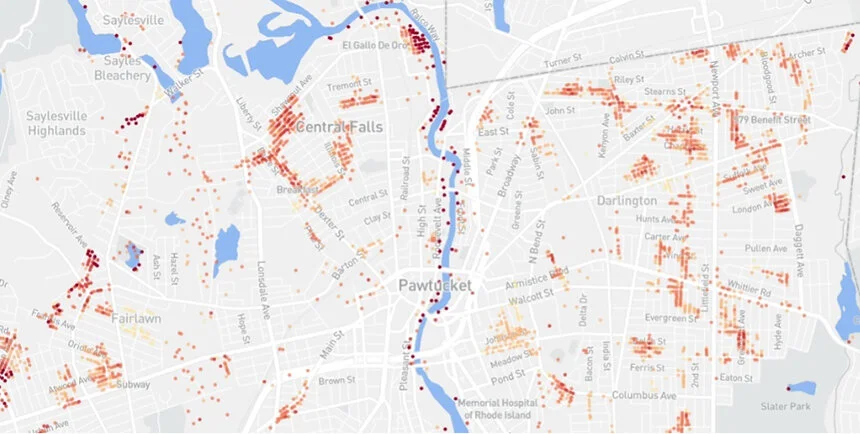
The flood risk map for
Central Falls and Pawtucket using FloodFactor data. (Roger Warburton/ecoRI
News)
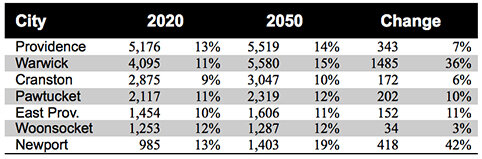
Rhode Island cities with
the greatest number of properties at risk of flooding.
The First Street
Foundation’s FloodFactor allows anyone to examine the flood risk of
their town, street, or even their individual property.
Providence has the
greatest number of properties at risk of flooding, with 5,200 currently at
risk, which is about 13 percent of the city’s total number of properties.
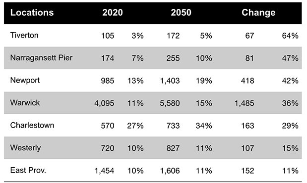
Rhode Island locations
with the greatest growing risk of properties being flooded.
Some Rhode Island
municipalities will see a massive increase in flood risk over the next 30
years. Some smaller Rhode Island communities, with fewer properties, have a
greater proportion of their properties at risk. Tiverton, for example, will see
a 64 percent increase in the number of properties at risk.
A warming Rhode Island
will result in rising marine waters, new weather patterns, and more frequent
and stronger storms. These factors intensify flooding from hurricanes and storms.
They also contribute to deeper floods that cause greater damage from even
modest events, such as heavy rains and king tides.
Roger Warburton, Ph.D.,
is a Newport, R.I., resident.