Menu Bar

Home           Calendar           Topics          Just Charlestown          About Us
Showing posts with label Sandy. Show all posts

Saturday, May 9, 2026

Major hurricanes in the Northeast are rare.

Could climate change make them common?

A black-and-white photo shows a two-story house carried away by waves
Figure 1. The storm surge of the 1938 Long Island Express hurricane washes away a home in Westport, Massachusetts. (Image credit: Westport Historical Society, CC BY-NC 2.0)

Since accurate records began in 1851, only two other major hurricanes made landfall in the Northeast U.S.: the 1938 Long Island Express Hurricane and an unnamed 1869 storm that hit Rhode Island (though there’s reason to be skeptical of the second one; in an email, historical hurricane expert Cary Mock said, “I doubt it would intensify that far north as a Cat 3.”) 

What about before accurate record-keeping began? Severe hurricanes that hit Long Island and then Connecticut in 1635 and 1815 were likely major hurricanes. A 2014 paper, Estimation of Hurricane Wind Speed Probabilities: Application to New York City and Other Coastal Locations, estimated that major hurricane wind speeds should occur about once every 300 years on Long Island and once every 700 years in New York City. 

Note that by” major hurricane," we mean one with sustained winds of at least 111 mph, making it a Category 3 on the Saffir-Simpson Scale. 

A large, west-angling hurricane like 2012's Sandy – discussed below – can deliver a catastrophic storm surge to the Northeast even if its winds decrease below the major-hurricane threshold just before landfall.

As the climate warms, at least four factors might increase the risk of a major hurricane in the northeast U.S.:

  1. Ocean warming is causing the strongest hurricanes to get stronger.
  2. A poleward shift in which hurricanes reach their peak intensity farther north (primarily because of warming sea surface temperatures)
  3. More hurricanes are forming close to the U.S. coast as a result of ocean warming.
  4. More Greenland blocking (a “stuck” jet stream pattern that increases the risk of a Northeast U.S. landfall)

One factor that might decrease risk: a tendency toward slower-moving storms, which would result in more weakening as they cross the cold waters offshore of the Northeast.

My hunch: these competing factors may act to modestly increase the major hurricane risk to the Northeast, so that a one-in-100-year storm of the 20th century would be roughly a one-in-75-year storm during the 2026-2050 period.

Monday, June 30, 2025

Trump’s Plan to Push FEMA’s Role to the States Will Be a Fiscal Disaster

Trump wants to end disaster assistance to the states

By Sarah LabowitzLeonardo Martinez-Diaz, and Debbra Goh , Emissary

When the next Sandy hits Rhode Island, are we going to be on our own? (Judy Gray)

The late spring and early summer are typically a time when the U.S. federal government prepares for hurricane season—the period from June 1 to November 30 that produces the biggest and most costly disasters in the United States. But this year is different.

Donald Trump and Homeland Security Secretary Kristi Noem continue to argue that FEMA, the primary federal disaster response organization, should cease to exist

There is no Senate-confirmed FEMA administrator because the White House has not nominated someone who meets the congressionally mandated basic qualifications for the role. 

Acting Administrator David Richardson still has not produced a viable plan for how FEMA will manage the hurricane season. The agency’s most experienced leadership has left or been forced out—most recently Jeremy Greenberg, who coordinated whole-of-government storm response. 

And the National Oceanic and Atmospheric Administration (NOAA) remains understaffed to perform critical weather forecasting functions that allow emergency managers to anticipate extreme weather conditions and position themselves for disaster response.

All of this makes the arrival of hurricane season unusually concerning. But three striking trends threaten to jeopardize a system already under strain: a backlog in federal disaster response requests, an inability of states to fill the federal funding gap, and a shift of accountability to states. Taken together, these factors could suggest major problems not just for the coasts, but for the whole country.

Sunday, June 1, 2025

NOAA’s 2025 hurricane forecast warns of a busy season

Endangered federal agency issues what could be its last hurricane season forecast

Colin Zarzycki, Penn State

U.S. forecasters are expecting an above-normal 2025 Atlantic hurricane season, with 13 to 19 named storms, and 6 to 10 of those becoming hurricanes.

Every year, the National Oceanic and Atmospheric Administration and other forecasters release preseason outlooks for the Atlantic’s hurricane season, which runs June 1 through Nov. 30.

But, how do they know what’s likely to happen months in the future?

I’m an atmospheric scientist who studies extreme weather. Let’s take a look at what Atlantic hurricane forecasts are based on and why those forecasts can shift during the season.

Tuesday, July 4, 2023

Will toxic haze and the 2023 danger season make a difference?

Believing the evidence of your own eyes (and lungs)

Derrick Z. Jackson for the Environmental Health News


The year is only half done and the United States has already been enveloped by acrid orange skies in the East, battered by winter rains and floods in California, seared by record winter temperatures in the South, soaked by a record 26-inch April deluge in Fort Lauderdale, and broiled by record spring heat in the Pacific NorthwestTexas, and Puerto Rico.

The onslaught has led to another round of media headlines and press releases from environmental and public health groups asking whether the nation is at a tipping point of urgency to fight climate change.

A Los Angeles Times headline for reader letters on the floods said, “California rains are a wake-up call for climate upheaval to come.” Many other media outlets and advocacy groups, from Al Jazeera to the American Lung Association, speculated as to whether the recent smoke plumes may also be such a “wake-up call.”

A Vox headline on the orange skies from Canadian wildfires said, “Wildfire smoke reminded people about climate change. How soon will they forget?” A Washington Post story carried the headline: “How the Canadian wildfire smoke could shift Americans’ views on climate.” A Philadelphia Inquirer column carried the headline, “America sleepwalks through a climate crisis. Will this smoke alarm wake us up?”

So far, no alarm bell has been loud enough to stop the sleepwalking. Hurricane Katrina in 2005, Superstorm Sandy in 2012, Hurricanes Harvey and Irma in 2017, and Hurricane Irma in 2021 were all accompanied by the same question. After the 2021 “heat dome” that saw Portland, Oregon hit 116 degrees and Seattle soar to 106, a Los Angeles Times headline said: “Northwest heat wave swamped the vulnerable, was a harsh climate wake-up call.”

The usual and eventual response to such things was summed up in an Associated Press story five years after Superstorm Sandy. The headline was “5 years after Superstorm Sandy, the lessons haven’t sunk in.” It was about most plans for climate security in the New York City area being unrealized.

Tuesday, February 7, 2023

New Flood Mitigation Project for Wood-Pawcatuck Watershed

Who will stop the rains?

By Cynthia Drummond / ecoRI News contributor

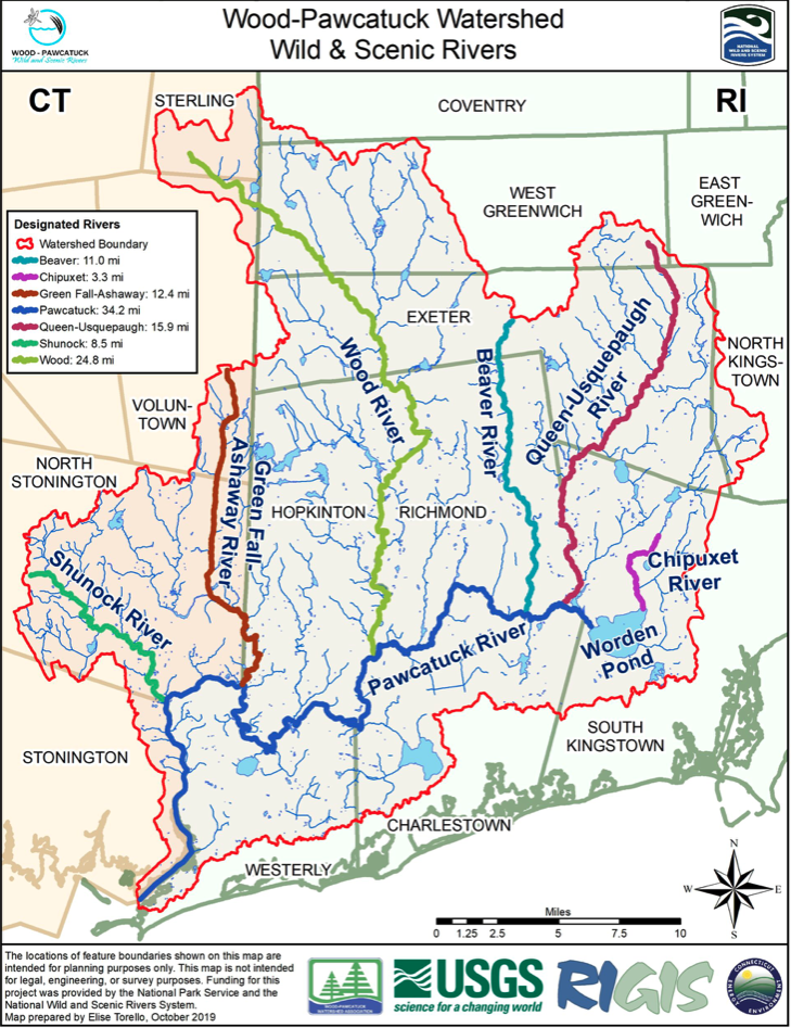
The Wood-Pawcatuck watershed includes seven rivers and
14 towns. (Wood-Pawcatuck Wild and Scenic Rivers
Stewardship Council)
Flood mitigation is once again on the government radar with a new study of the Wood-Pawcatuck watershed.

An overview of the “Wood-Pawcatuck Rivers Flood Protection Project,” administered by the Natural Resources Conservation Service (NRCS) of the U.S. Department of Agriculture (USDA), was unveiled to residents of the communities in the watershed and state representatives last month.

The examination follows an earlier study of the watershed, conducted in 2017 by the engineering firm Fuss & O’Neil and funded by $720,000 from the Hurricane Sandy Coastal Resiliency Competitive Grant Program.

NRCS representatives did not say how much the new flood mitigation project will cost.

“You’ve already completed an initial study that was published in 2017,” consulting engineer J. Matthew Bellisle said. “We’re going to be building on that.”

Bellisle’s firm, the Pare Corporation of Lincoln, has been hired by the NRCS to do the new study.

“The NRCS was brought into this because a number of local groups approached us and said, ‘We have some flooding problems. We would like to study these, but we want some assistance,’” he said.

Spanning southern Rhode Island and eastern Connecticut, the Wood-Pawcatuck watershed is extensive, comprising 300 square miles and touching 14 communities. In addition to the Wood and Pawcatuck rivers, the watershed includes 14 tributaries and, in 2019, received a National Wild and Scenic River designation from the National Park Service.

Thursday, November 10, 2022

Superstorm Sandy Showed Ocean State What Future Storms Could Look Like

And what have we learned?

By Cynthia Drummond / ecoRI News contributor

More frequent and intense weather events and major storms, such as Superstorm Sandy in 2012, are taking a toll on Block Island’s coastline. (Judy Gray)

Superstorm Sandy was a complex, hybrid storm, the result of warm tropical air colliding with cold northern air. The storm reached Rhode Island on Oct. 29, 2012, causing significant damage to coastal homes and businesses. The National Flood Insurance Program paid more than $31 million in claims from Rhode Island alone.

Now, a decade later, researchers are developing ways to predict how severe storms will impact coastal communities.

Isaac Ginis, a professor at the University of Rhode Island’s Graduate School of Oceanography, develops storm-intensity prediction models, including a computer model used by the National Weather Service. Ginis described Sandy as the type of intense storm that might strike Rhode Island more often in the fall and winter.

“This happens in the winter time, when the temperature over land is getting colder and colder,” he said. “We typically have cooler air sliding down from Canada and then, the temperature of the water is still warm.”

That temperature difference, or gradient, produces nor’easters. As Sandy approached New England, getting energy from the warmer ocean water, Ginis explained the storm also began to draw energy from the atmosphere, with its warm/cold air temperature difference.

Saturday, November 5, 2022

The environment gets orphaned yet again.

Election Day and beyond

Peter Dykstra for Environmental Health News

There’s no doubt that there’s plenty for House and Senate candidates to talk about as the midterm elections near: inflation, gasoline prices, Putin and Ukraine, Xi and China, race and crime, guns, education, immigration and more.

But all of these issues have crowded out – once again – the only issue that’s certain to be with us 30, 50 or even 100 years from now: climate change and environment.

Sunday, March 27, 2022

Sea level rise and storms pose greatest risk to Charlestown

UPDATED: But many Charlestown shoreline owners don’t give a crap

By Will Collette

Joanna Detz/ecoRI News
WPRI’s Target 12 investigative team just released a devastating report that makes many of Charlestown’s richest people look pretty stupid.

According to the First Street Foundation that specializes in monitoring flood risk, Charlestown has the greatest proportion of properties at risk of flooding in Rhode Island.

Even though there is federal financial support available to raise their homes up and (hopefully) above storm surge, only 38% of eligible homeowners have taken the initial step, the design phase. That’s 17 of a total of 45 eligible properties. Under the federal program, the feds will pay 65% of the cost of raising a house above the danger level.

As Superstorm Sandy proved in 2012, a major storm will cause catastrophic damage. Such storms will become more frequent, plus sea level will continue to rise.

This GIF was created by WPRI for its story on Charlestown's lack of participation in the federal program to storm proof homes. It shows the level of inundation from a 100-year flood, of the type we get more frequently these days.

Channel 12 estimated that, depending on the size of the house, the cost share under the federal program to the homeowner would be between $45,000 and $89,000.

Since so many of these properties are valued at $1 million or more, sometimes a lot more, and there are insurance savings to be had, the lack of participation is baffling.

Our Zoning Officer Joe Warner told Channel 12 “It’s certainly intriguing that we didn’t have more interest because that’s a pretty big percentage [65%] to be paid for.”

Charlestown is not alone when it comes to apathy to flooding from climate change, especially among the wealthy. A recent Georgia State University study of coastal home buying in Florida showed there was almost no effect on home buying in flood-threatened areas even though sellers are required to disclose the risk.

Part of the problem is that mortgage lenders and many appraisers were not including flood damage potential in their determinations of home value even though flood insurance sellers were. But wealthy buyers who pay cash aren’t required to purchase flood insurance.

They may be sanguine about storm damage, thinking they can afford to simply repair or rebuild. Maybe they can do that in Florida but under Rhode Island CRMC rules, if a coastal property suffers 50% or more damage from a storm, the property may not be rebuilt.

The WPRI report quotes CRMC spokesperson Laura Dwyer who cites this CRMC regulation:

“…all residential and non-water dependent recreational, commercial, and industrial structures on undeveloped barriers physically destroyed fifty percent (50%) or more by storm induced flooding, wave or wind damage may not be reconstructed regardless of the insurance coverage carried.

Joe Warner, for his part, has done everything he can to help coastal homeowners. He’s taken courses, won certifications and taken measures to secure the highest rating from FEMA for Charlestown’s emergency preparedness. Joe’s efforts have substantially cut the insurance cost for these properties.

But property owners’ failure to elevate their structures might affect that rating as the climate crisis worsens.

Joe also noted that the federal assistance program only covers a small fraction of endangered properties:

“[The Army Corps of Engineers] only came up with 45 properties and we have hundreds, if not thousands that are potentially in harm’s way.”

If anyone in town would know this, it’s Joe. But his estimate has some back up from the First Street Foundation who say:

“There are 500 properties in Charlestown that have a greater than a 26% of being severely affected by flooding over the next 30 years. This represents 23% of all properties in the city.”

There is a strong political dimension to this problem. The Charlestown Citizens Alliance (CCA) counts on wealthy shoreline residents as its core support for campaign funding. Those shoreline properties are also a big part of Charlestown’s tax base.

For those reasons, the CCA and the town have a pretty strong self-interest to keep those properties from being blown and washed away in the next inevitable major storm.

A NASA satellite, Sentinel 6, is constantly measuring sea levels, the newest
of several satellites providing critical data about the climate crisis. 
This animation shows the radar pulse from the Sentinel-6 Michael Freilich
satellite’s altimeter bouncing off the sea surface in order to measure the
height of the ocean. Credit: NASA/JPL-Caltech
But fear not, we have a new Charlestown Climate Resiliency Commission. It has had at least one meeting and has a link to draft minutes posted on the town website.
But WARNING: do not click on that link – when I did, my anti-virus software immediately signaled the link is contaminated with a serious virus. Town Hall says the link is clean. It could have been a false alarm from my Afee software. - WC

Hopefully, they’ll get that fixed quickly.

This Commission has the following mission:

Study and analyze issues and impacts of climate change and global warming, development of strategies, policies and plans for mitigation of and adaptation to impacts from climate change and global warming.

There are a veritable legion of scientists and experts already studying the effects of the climate crisis on the New England coastline and we already know what is most likely going to happen to Charlestown.

For example, there is a newly released National Oceanic and Atmospheric Administration’s 2022 Sea Level Rise Technical Report. Frank Carini at EcoRI writes about this report HERE.

This Commission may have some talented people on it, but I hope they are smart enough not to waste time duplicating the efforts of federal, state, university, non-profit and businesses who have already done the science.

Illegal in Charlestown
I believe this Commission will most likely turn its attention to what it will do about the likely damage increased bad weather and sea level rise will do to people and property.

I hope this Commission will also recommend that Charlestown puts more effort into reducing carbon emissions and increasing the use of green energy. Better late than never.

New wind wall: Illegal in Charlestown
Charlestown still has an onerous ordinance passed in 2011 that makes small residential wind turbines impossible to get. Indeed, not one single residential wind turbine permit has been issued in the eleven years since the ordinance was passed. That must change.

Charlestown should restart its Solarize Charlestown program and also launch other group-buying efforts to help property owners make the switch to green energy. Solarize Charlestown was the only town effort to promote the switch to green energy but it only lasted a few months in 2017 and less than 40 households participated (mine was one of them – best decision we made).

We had these panels installed under Solarize Charlestown in Nov. 2017.
Since then, they have saved us thousands in lower electric bills
and rebate checks from National Grid, (Photo by Will Collette)
The town should also offer property tax credits for green energy installations and for investments in resilience (e.g. hurricane proof windows, shutters and doors, metal roofs).

These measures are in line with global and national efforts to try to slow down the climate crisis but it’s not going to stop the storms.

I have raised concerns in the past that perhaps one of the driving forces behind the Budget Commission and CCA effort to raise taxes so we can build up a huge budget surplus to use as a bail-out fund for Charlestown’s beach property owners.

Chair of Charlestown Budget Commission, explaining $3 million "oopsie"
The CCA Council majority just passed a “plan” for the town’s unassigned fund balance (a.k.a. surplus) that anticipates building up this surplus to $10 million from its current $5 million and change. This is WAY above the normal recommended level.

As we all discovered in January, the Charlestown Budget Commission accidentally spent $3 million it thought it had in unassigned surplus funds because of an “oopsie” that assigned those $3 million to another purpose.

I am concerned the CCA and the Budget Commission will use the new Climate Resiliency Commission to provide political cover so they can raise taxes in the budget due to go into effect July 1 (assuming voter approval) to rebuild the surplus money pool.

What the Climate Resiliency Commission can actually do to guide Charlestown through the climate crisis remains to be seen though I do wish them luck.

Wednesday, December 1, 2021

How will Charlestown use its federal bonanza?

Stankiewicz unveils vision of how Charlestown will use its COVID funding, if it ever does

By Will Collette

His secret power is he can makes things go very slooooooow
Normally, it takes a pry bar or a court order to get any substantive information from Charlestown’s Town Administrator Mark Stankiewicz. 

His extraordinary efforts to block the release of any information not in the interests of his masters in the Charlestown Citizens Alliance (CCA) have earned him the nickname of Stonewall Stankiewicz.

Apparently, I’m not the only one being stonewalled by Stankiewicz. After writing THIS ARTICLE, I’ve heard from other Charlestown residents who have also have had open records responses containing page after page of blacked-out records or a huge bill, payable in advance, to get page after page of blacked out records.

Like me, they were looking to uncover evidence of town malfeasance in road projects, construction, land deals, town finances, the use of town resources for political ends, and more. Like me, they’ve been told to pay hundred-plus to find that the most information has either been withheld or blacked out.

This is typical of hundreds of open records requests
I've gotten from Stankiewicz. Very transparent, right!
Stankiewicz has made a science of searching the state’s Access to Public Records Act (APRA) looking for ways to deny release of records on such topics. He’s even drawn a rebuke from the Assistant Attorney General in charge of open government who noted that even though the law may allow a town to withhold certain information, that doesn’t mean they should.

So you could knock me over with a feather last Friday when I read a Providence Journal article that reviewed how cities and towns across the state planned to use federal monies allocated to them under the American Rescue Plan Act (ARPA, not to be confused with APRA). This is part of Joe Biden’s COVID relief program and is aimed at helping state and local governments recover from the pandemic.

It’s an interesting article loaded with useful ideas about how the money can and is being used by other municipalities around the state.

Note that cities and towns were told last May how much money was coming. I published THIS ARTICLE with that information on May 11.

Here’s the Charlestown section from the article:

Charlestown

Total expected: $2.3 million

Total committed: $0

What's happening: "We’re playing it slow," said Town Administrator Mark S. Stankiewicz. 

The small town has an equally small staff, and those employees have limited bandwidth and aren't necessarily "attuned to all the ins and outs of federal regulations," Stankiewicz said. As a result, Charlestown will likely hire an outside consultant to figure out how to best use the money without running afoul of any guidelines. 

While other communities have invested in upgrading municipal water and sewer infrastructure, Charlestown doesn't even have those facilities in the first place, Stankiewicz pointed out. 

Input from community members will be solicited at some point, but Stankiewicz says he wants to first get a clearer understanding of what uses are allowed.

"It’s a pie that everyone wants a slice of," he said. "And the pie is limited."

Well now, I never realized that Mark Stankiewicz is making policy for the town. Or that he is hiring consultants he has not been authorized to hire. Prior townadministrators would have been hung, drawn and quartered by the CCA for doing that.

Charlestown's Town Charter was carefully crafted and amended to place all power in the Town Council, not the Town Manager. However, maybe Stankiewicz is testing unlimited new powers granted to him by the Council's CCA majority, led by Bonnie Van Slyke (Arnolda) to fight what we now know is an imaginary threat from AMTRAK.

For a guy who says very little and usually parses his words very carefully to avoid giving away any useful information, it seems that ProJo report Antonia Noori Farzan peeled Stankiewicz open like a can of cat food.

Let’s start with “We’re playing it slow.” Given that ARPA money is supposed to be used to stimulate the economy, “playing it slow” kinda misses the point.

Is “playing it slow” Charlestown’s policy? Most cities and towns around the state have been looking forward to this money since it was first announced in May and already have plans. A couple have already committed all or much of the money.

Bristol, for example, has committed nearly all of its money to infrastructure projects, many dealing with neighborhood flooding. West Warwick is using half a million as bonuses to reward first responders for their service during the pandemic. Portsmouth will use $1.5 million to launch a revolving capital fund for public service vehicles and equipment.

A couple of towns plan to do what Stankiewicz proposes, which is hire consultants to help them spend the money. Apparently a new cottage consulting industry has sprung up. Stankiewicz has been increasingly reliant on outside consultants rather than do the work himself or delegating it to staff. Maybe this next bit explains why.

Stankiewicz says his staff has "limited bandwidth" and
aren't "attuned" to federal regulations" Whose fault is that?
 
Then there’s Stankiewicz’s demeaning description of Town Hall staff who “have limited bandwidth and aren't necessarily attuned to all the ins and outs of federal regulations.” 

Is this Stankiewicz’s admission that since he was hired in February 2013, he has failed to build a competent staff who, in particular, don’t know how to handle federal funding?

WTF?!?

For just about all the Town Hall staff, this is hardly their first rodeo in handling federal funds. Remember Superstorm Sandy? Winter storm Nemo? Every weather-related disaster declaration has been followed by federal funding and this ARPA funding is no different.

I do recognize that at least one Town Hall staff has a problem with rules and regulations, Town Planner Jane Weidman, minion of Planning Commissar Ruth Platner. She started off the SPA-Gate scandal in 2020 by filling an application for DEM funding to buy a piece of land worth around $70,000 for a price tag of $423,000.

The price tag was based on a very shaky assessment done for the Sachem Passage Association that Weidman knew was shaky. Why? Because Charlestown Tax Assessor Ken Swain gave her detailed reasons why the land was not worth $423,000 three days before she filed the application.

Filing that application would, in my opinion, violate this section of the RI General Laws:

§ 11-18-1 Giving false document to agent, employee, or public official. – (a) No person shall knowingly give to any agent, employee, servant in public or private employ, or public official any receipt, account, or other document in respect of which the principal, master, or employer, or state, city, or town of which he or she is an official is interested, which contains any statement which is false or erroneous, or defective in any important particular, and which, to his or her knowledge, is intended to mislead the principal, master, employer, or state, city, or town of which he or she is an official.

(b) Any person who violates any of the provisions of this section shall be deemed guilty of a misdemeanor, and, upon conviction, shall be imprisoned, with or without hard labor, for a term not exceeding one year or be fined not exceeding one thousand dollars ($1,000).

Weidman, Platner and Stankiewicz did the same thing earlier this year to buy the Tucker Estates property at the behest of the CCA. They ignored the tax assessment of $333,600 and instead used three successive assessments (based on “hypothetical assumptions”) to finally get to the seller’s desired price of $900,000!

Then Platner wrote an defense of this blatant rip-off claiming “Buying Tucker Woods Was A Good Land Deal.”

Yeah, maybe Stankiewicz is right about town employees not knowing how to stay out of trouble with the law. The statute of limitations to prosecute on these deals has not run out.

That brings me to my final point on Stankiewicz’s 15 minutes of fame in the ProJo. I think the real reason he’s talking about stalling and hiring a consultant is that he’s looking to see if Charlestown can use the ARPA money to buy more properties on Ruth Platner’s Christmas list.

Saturday, June 5, 2021

Fighting the mess in Green Hill Pond

Friends Rally to Revive Coastal Pond Besieged by Pollution

By GRACE KELLY/ecoRI News contributor

Development around the pond and its inability to be properly flushed has saddled Green Hill Pond with high levels of nitrogen and bacteria. (Tom Wojick/for ecoRI News)

Where the land meets the sea, and where South Kingstown brushes hands with Charlestown, a complicated salt pond makes its Rhode Island home.

Green Hill Pond is mostly closed off from the nearby Atlantic Ocean by a thin barrier beach, save for a small inlet between it and Ninigret Pond. It’s a beautiful, if somewhat tortured, pond with a number of problems stacked against it: high nitrogen and bacteria levels; a lack of adequate flushing; and flooding when storms push salt water over the beach to its south.

When Superstorm Sandy hit in 2012, a portion of the dunes were overtopped, and the pond’s water level rose 4 feet.

“That gets your attention,” said Dennis Bowman, president of the Friends of Green Hill Pond, a nonprofit dedicated to reviving the beleaguered waterbody.

But the pond’s history shows brighter days, when men and women of the sea would bring rakes, buckets and bags and dig through the mud for oysters and clams.

In a 1964 letter from U.S. Fish & Wildlife Service regional director Eugene Crawford to the Army Corps of Engineers, Crawford wrote, “A large annual oyster harvest is being taken from Green Hill Pond. About eight commercial oystermen work the pond and many persons harvest oysters for personal use. The harvest is valued at $6 to $7 per bushel. It is estimated that $30,000 to $40,000 worth of oysters have been taken from the pond annually during the past years.”

Today, no one harvests oysters from Green Hill Pond. No one has since the 1990s, because of high levels of nonpoint source pollution such as stormwater runoff that contains excess nitrogen from fertilizers. Bacteria from faulty septic systems and outdated cesspools also plays a role in the pond’s degradation.

The salt pond region of southern Rhode Island extends from Maschaug Pond in Westerly to Point Judith Pond in Narragansett and forms the natural boundary between Block Island Sound and a shallow freshwater aquifer. This watershed is so built up that important ecosystems are under relentless pressure.

In Charlestown, for instance, its three coastal salt ponds — Quonochontaug, Ninigret and Green Hill — are being negatively impacted by a high concentration of housing and development. It’s a problem up and down most of South County’s open-ocean shoreline.

Monday, May 31, 2021

“We pissed away most of the time we had to address these impacts”

South County Coastline Fades Away as Carbon Emissions Pile Up

By FRANK CARINI/ecoRI News staff

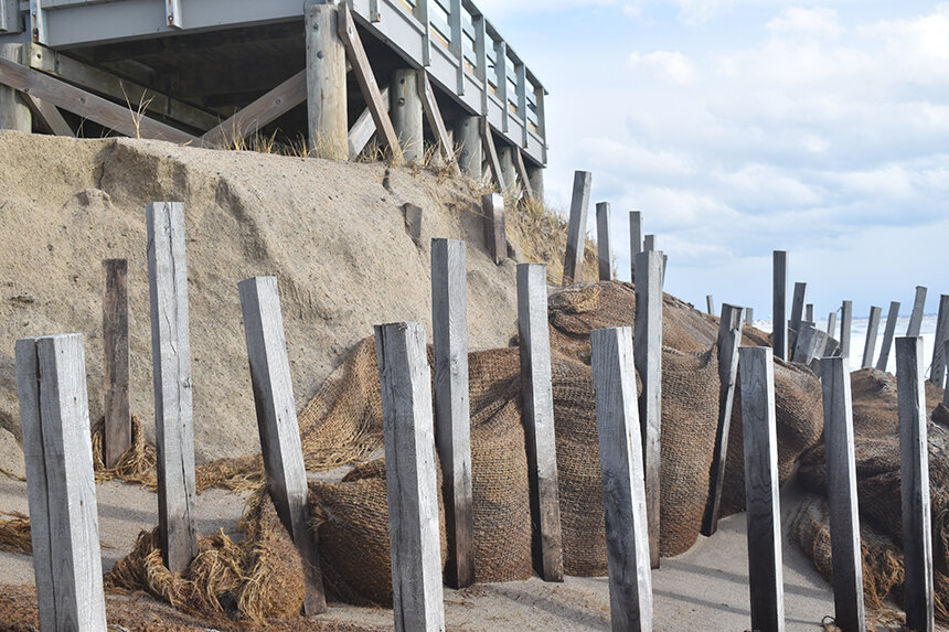
A century-plus of guzzling fossil fuels has concentrated a growing amount of heat-trapping greenhouse gases in the atmosphere, resulting in rising sea levels and warmer ocean waters. The consequences can been seen along much of the Rhode Island shoreline. (Frank Carini/ecoRI News)

Along the Rhode Island coast from Watch Hill to Point Judith, change is happening fast. From 5,000 to 150 years ago, coastal erosion along this stretch of open-ocean shoreline held steady, but it accelerated as our fondness for burning fossil fuels grew.

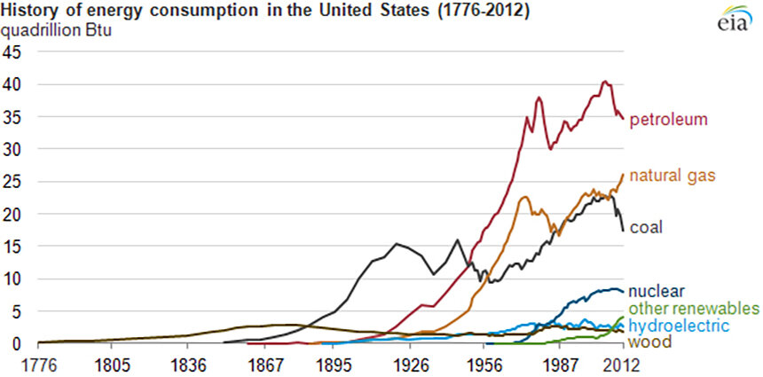
Coal became dominant in the late 19th century before being overtaken by petroleum products, such as oil, gasoline and diesel, in the middle of the past century. Natural gas is now the dominate fossil fuel.

The buildup of greenhouse-gas emissions in the atmosphere has taken a bite out of the Ocean State’s South County coast. Erosion rates are increasing and the volume of sand is decreasing, according to John King, a longtime professor at the University of Rhode Island’s Graduate School of Oceanography.

Beaches and the sand upon them protect the land behind them. Rhode Island is losing a natural defender of its developed coastline, and upland sand resources won’t last forever, even if taxpayer funding could.

The three major fossil fuels — coal, petroleum and natural gas — have dominated the U.S. fuel mix for more than a century. (EIA)

EDITOR'S NOTE: In its frantic fight to block the unpopular Whalerock industrial wind turbine project from being built along the ridgeline north of Route One, Charlestown embraced a fact-free position opposing ALL wind energy and effectively banning even small residential wind generators. This was done by enacting Ordinance 344 in November 2011 that set conditions that made it impossible to install a residential wind generator of any kind. In the 10 years since that ordinance was enacted, not one single permit has been issued by Charlestown to install a residential wind generator. - Will Collette

Saturday, May 22, 2021

Climate change could wipe out our neighbors

Matunuck Village One Big Storm Away from Substantial Destruction

By FRANK CARINI/ecoRI News staff

The problem of disappearing Matunuck Beach goes well beyond the future of Ocean Mist and the other right-on-the-water buildings there. (Frank Carini/ecoRI News photos)

Last year, two days after a Nov. 30 offshore storm pelted Rhode Island’s coast, especially its open-ocean shoreline, with waves, wind and rain, a turbulent sea lingered along two beaches in this vulnerable seaside town.

Both South Kingstown Town Beach and Matunuck Beach showed signs of “dramatic changes,” according to David Prescott, Save The Bay’s South County coastkeeper. He noted that the accumulating impacts of these more frequent and intense storms are taking a toll.

“These storms are doing damage. This is crazy,” said Prescott, standing on South Kingstown Town Beach during a cold and windy Dec. 2 weekday. “Coastal dynamics are always changing, but climate change complicates the process. These winter and spring storms hammer the coast from one tide cycle to the next.”

Town Beach, under the relentless pounding of waves, never-ending tide cycles and climate-fueled storms, is retreating at a rate of about 5 feet annually. About a mile away, Matunuck Beach, once a sandy carpet that fronted Matunuck Beach Road and Ocean Mist, a popular beach bar, is being chewed up at a significant rate, with some areas losing more than 100 feet since 1939.

Beachfront bars and restaurants, supported by a maze of wooden beams, jut out over breaking waves, as seawater routinely laps beneath the at-risk structures.

The problem of disappearing Matunuck Beach goes well beyond the future of Ocean Mist and the other right-on-the-water buildings, however. The village of Matunuck, home to about 500 residences and several businesses, is a big hurricane away from experiencing some serious damage.

The 4-foot-high seawall built and being expanded will do little to protect the neighborhood from a 100-year storm, like the one that hit in 1938. Prescott noted that the debris field created by the hurricane of 1938 reached all the way to Route 1.

Saturday, February 27, 2021

March 9: Free on-line program on preparing for the coming major floods

Coastal State Discussion Webinar: The Future of Coastal Megaprojects

Monica Allard Cox


Rhode Island is long overdue for a major hurricane. Even a brush with Superstorm Sandy in 2012, which caused $11.2 million in damages and left 122,000 Rhode Islanders without power, was not a worst-case scenario, but a reminder of the state’s exposure and vulnerability. 

And a record-setting hurricane season in 2020 with 30 named storms, 12 of which made landfall in the U.S., was another reminder of how a changing climate makes rising seas and storm flooding more devastating.

Storm surge barriers, levees, and other coastal flood protection megaprojects are being investigated as strategies to protect U.S. cities against devastating coastal storms and rising sea levels. But these projects are large scale and complex, often taking years to decades to complete and costing billions of dollars with long-lasting impacts on the economy, environment, and society. 

Additional layers of social conflict and other political factors also cast doubt on their ability to serve as practical climate adaptation options.

On March 9 from 3 to 5 p.m., Paul Kirshen, professor of climate adaptation at the University of Massachusetts Boston, and D.J. Rasmussen, an engineer and climate scientist who recently graduated from Princeton University’s School of Public Policy & International Affairs, will discuss the technical, environmental, economic, and political factors of why some coastal flood protection megastructures break ground in the U.S. while others do not, using Boston Harbor and Rhode Island’s Fox Point Hurricane Barrier in Providence–the first gated hurricane-protection structure in the U.S.– as case studies.

Monday, February 22, 2021

One month in, how Biden has changed disaster management and the US COVID-19 response

It's nice to have a guy in charge who actually wants to stop the pandemic

Brian J. GerberArizona State University and Melanie GallArizona State University

The National Guard joined forces with FEMA to launch a
mass vaccination site in Los Angeles. 
Frederic J. Brown/AFP via Getty Images
After one month in office, the Biden administration has fundamentally changed how the federal government responds to the COVID-19 pandemic.

In direct contrast to his predecessor, President Joe Biden is treating this as a national-scale crisis requiring a comprehensive national strategy and federal resources. 

If that sounds familiar, it should: It’s a return to a traditional – and in many ways proven – approach to disaster management.

The Trump administration deviated dramatically from established emergency management practices. 

It politicized public health and related decision-making processes and overrode the disaster response roles of federal agencies, including the Centers for Disease Control and Prevention, the Department of Health and Human Services and the Federal Emergency Management Agency.

Among other things, the Trump administration established an entirely new coordination structure headed by a White House task force, then changed the lead federal agency from Health and Human Services to FEMA. 

Those moves, combined with a disjointed array of other operational task forces, made it difficult to create an integrated response. Even basic data collection from hospitals for tracking the coronavirus’s spread was thrown into disarray by changes.

The Biden administration is now re-empowering key federal agencies to return to the roles and responsibilities they were designed for within a planned national disaster management structure.

Our own work in hazards management, with both governments and nongovernmental organizations, has shown us that fidelity to proper process and respect for expertise is essential to effective disaster management. The Biden administration’s approach to the pandemic so far suggests this is the model it will follow.