Barrington, South Kingstown, Westerly (but not Charlestown) are CoastSnap kickoff municipalities
 |
| From left, Jennifer Ogren, assistant administrator for Rhode Island State Parks; Pam Rubinoff, coastal resilience specialist for the URI Coastal Research Center and R.I. Sea Grant; and graduate student Sarah Schechter pose with the CoastSnap shoreline monitoring cradle at Misquamicut State Beach in Westerly. (URI Photos by Michael Salerno) |
New equipment at three Rhode Island coastal sites now enables the public to use smartphones to take photos that could help government collect data on climate change impacts such as flooding and erosion, and ultimately inform practical planning and projects to address them.
In the vein of “community scientist”
education efforts, this program provides the state and a municipal cadre – the
towns of Barrington, South Kingstown,
and Westerly – an opportunity to engage communities in
“app” based shoreline monitoring.
Using the equipment – a cell phone cradle – that has been installed at the three coastal locations, people can take photos at the sites and upload them to CoastSnap, an app for online photo collection and crowdsourcing. The set cradle position at each site ensures that all photos are taken from the same view and can be combined into time-lapse video sequences showing shoreline change. Change can occur, for example, with flooding and erosion tied to strong storms, tides, and sea-level rise.
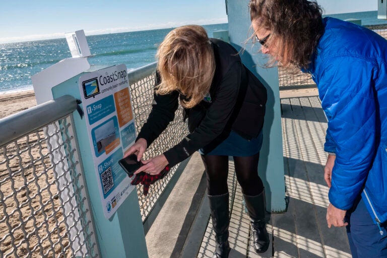 |
| Ogren and Rubinoff scan the QR code on the CoastSnap cradle, which community photographers can use to submit a photo that will help government agencies monitor the changing coastline. |
The
public is welcome to participate as shoreline monitors by visiting the
municipal CoastSnap sites: Latham Park in Barrington, East Matunuck State Beach
in South Kingstown, and Misquamicut State Beach in Westerly. Instructional
signage is on-site at each location to guide picture taking and uploading to
CoastSnap, an online platform created by the University of New South Wales,
Australia, and active in 22 countries.
Led
by the University of Rhode Island, the Coastal Resources Center and Rhode
Island Sea Grant, both located at the URI Graduate School of Oceanography, the
project includes the Rhode Island Department of Environmental Management, which
serves as both state site provider and cradle installer. On the municipal
level, Barrington, South Kingstown, and Westerly are taking part to bolster
community education and evidence collection regarding coastal change.
“Our
hope is that community members gain an easy and enjoyable means of contributing
to local-level efforts to address climate change impacts,” says Pam Rubinoff, a
resilience specialist for URI CRC/Sea Grant leading the app effort, “while
government decision-makers and staff can consider how crowd-gathered and shared
visual evidence can support resilience planning.”
“Sea-level rise speeds up and worsens the natural coastal erosion that’s continually taking place in Rhode Island, where in the last 90 years, the sea level has risen nearly a foot,” said DEM Director Terry Gray.
“This already is affecting
the eight state surf beaches that DEM manages that more than a million people
flock to every summer. For this reason, along with our deep belief in community
science initiatives, DEM strongly supports this. We encourage visitors to East
Matunuck and Misquamicut state beaches to snap pictures and help document the
changes to our shoreline.”
For
Barrington, the Latham Park site is ideal for the CoastSnap project as the work
will dovetail with a planned shoreline stabilization project. “The coastline at
Latham Park is eroding, so this effort, tied to our stabilization project, will
allow us to evaluate post-construction project success,” says Teresa Crean,
director of Planning, Building, and Resiliency for the Town of Barrington. “We
also expect the CoastSnap station will educate residents and document high- and
low-tide levels at the park.”
In
related work, URI CRC/Sea Grant is also working to introduce another shoreline
monitoring app to local communities. MyCoastRI (https://mycoast.org/ri) supports the collection and
sharing of smartphone photos depicting coastal change, including flooding,
erosion, and marine debris. Partners for this work are Save The Bay, Clean
Ocean Access, and the Rhode Island Coastal Resources Management Council.
URI
CRC/Sea Grant carries out its community shoreline monitoring work with funding
from the National Oceanic and Atmospheric Administration. All state partners
and the Town of Barrington are providing staffing resources to support the
implementation and maintenance of the CoastSnap equipment stations.
Community
members wishing to make use of either app can follow these instructions:
COASTSNAP: Place a
smartphone horizontally on the cradle mechanism, take a picture of the site,
and upload the photo to the CoastSnap web portal using a QR code, depicted on
the onsite instructional signage guiding community photographers.
MYCOASTRI: Visit https://mycoast.org/ri to
view the brief instructional video and upload photos of high-tides, storm
flooding, erosion, or storm debris/damage to the crowdsource database.
If
you have questions about using the app, contact Pam Rubinoff at rubinoff@uri.edu.
For more information on the program, contact Sue Kennedy at sbkennedy@uri.edu or
401-450-2666