The much misunderstood RI Supreme Court's four-decade-old shoreline access decision
By ROB SMITH/ecoRI News staff
Rhode Island attorneys
and property owners may have to accept the idea of a dynamic and constantly
changing shoreline boundary. 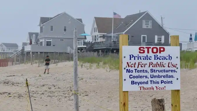
Photo by Steve Ahlquist, UpRiseRI
The state’s 12-member House commission to study
shoreline access issues recently heard from a group of experts about the legal
and scientific difficulties of finding a fixed, permanent boundary on the
state’s ocean-facing properties.
It is an annual problem as sure as the ebb and flow of tides. The Rhode Island Constitution enshrines access to “the privileges of the shore.” But where do those privileges end, and where does trespassing on private property begin?
Property
owners have always argued against letting the public onto beaches they claim to
own, claiming it constitutes an illegal seizing of their property. Shoreline
activists say this conflicts with their constitutional rights to the shore.
The problem comes down
to where the line is exactly drawn in the sand. A 1982 Rhode Island Supreme
Court decision, State v. Ibbison, set
the line at the high-water mark or the mean high tide line (MHW), defined as
the average of 18.6 years of data derived from tidal gauges. But the MHW line
is either underwater or not identifiable by the casual beachgoer.
“What can be seen is the last high tide swash, the extent that the beach got wet at the last high tide at any given day,” Nathan Vinhateiro, assistant director at University of Rhode Island’s Coastal Institute, said during an Oct. 14 online meeting of the House commission.
URI has collected data
on Rhode Island’s beaches since 1962, generating beach profiles from Napatree
Point in Westerly to Point Judith in Narragansett. Student researchers go out
and survey the state’s beaches every two weeks —in June, July, and August the
surveys are only performed once a month — taking note of the last high tide
swash line (LHTS) over time.
“The last high tide
swash line is always landward of the mean high tide line,” Vinhateiro said.
The URI data showed on
average that the LHTS was 40-60 feet landward compared to the mean high tide
line. The MHW and the private boundary is actually a lot more seaward than most
people think.
MHW is tough to measure,
typically requiring sophisticated scientific equipment. But the line is always
changing, “basically with each wave.” The tidal data sets issued by the
National Oceanic and Atmospheric Administration every 18.6 years do not account
for the normal processes on the beach: sand accretion; the movement of sand;
erosion; damage from intense storms and hurricanes.
This summer, URI
researchers investigated the MHW, monitoring every month on specific days how
long the public can reasonably access the shore without trespassing. Using
real-time kinematic global positioning system (GPS) instruments, they would
locate the MHW on the spot, stake the location, and take notes on water levels
as the tide flowed in and out.
Their findings show
there is only a 30-minute period during a tide cycle where there is a walkable
beach 6 feet wide, the minimum amount of space needed for two people to walk
side by side. The data shows the MHW is only available two hours before low
tide and two hours after low tide.
“What we’re finding more
often than not, if you are on the beach and your feet aren’t wet, you are above
that Ibbison line,” Vinhateiro said.
The special commission also
heard from one of its own members. Dennis Nixon, a legal expert in shoreline
access and retired URI professor, presented a legal and constitutional history
of shoreline access in Rhode Island. He said the constitutional right to
shoreline access is illusory unless the state decriminalizes trespassing on the
shoreline or sets the legal property boundary higher at the last high tide
swash line.
“When you choose to live
at the water’s edge, you choose to live next to the public’s submerged land
that moves,” Nixon said.
He disputed the traditional legal arguments from property owners, that letting the public on the shore would damage property, depress values, or constitute the government seizing property. He compared the right to shoreline access to a city sidewalk.
People are allowed to pass along the sidewalk but not host parties or play loud
music. A sidewalk is not a permanent extraction from property owners, Nixon
said, it is a temporary usage and a public right of passage.
Existing state law
already exempts waterfront property owners from legal liability. If a member of
the public is not trespassing on the shore and they injure themselves, the
property owner cannot be sued for damages.
Some on the commission
members questioned if opening the beach further to the public would provide
certainty in the legal profession. Nixon said there already was deep
uncertainty in property deeds and the law. Deeds for waterfront properties
traditionally set the boundary at the body of water, but the shoreline is
constantly changing, which means the property line is constantly changing.
“The law has to embrace
a dynamic shoreline,” Nixon said.