Who will stop the rains?
By Cynthia Drummond / ecoRI News contributor
Flood mitigation
is once again on the government radar with a new study of the Wood-Pawcatuck
watershed.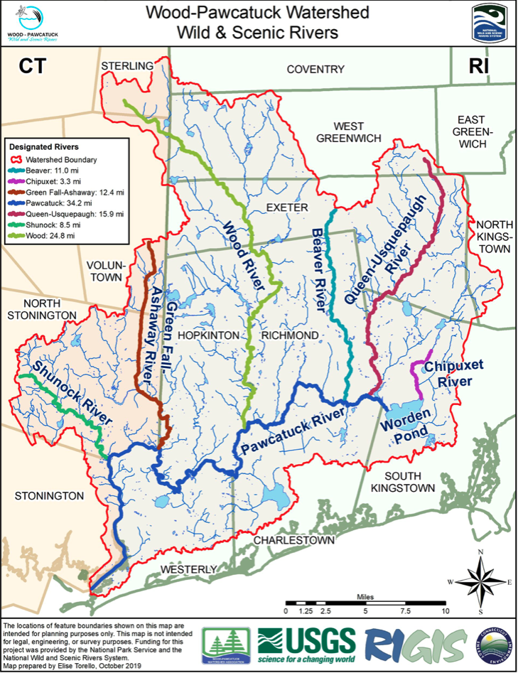
The Wood-Pawcatuck watershed includes seven rivers and
14 towns. (Wood-Pawcatuck Wild and Scenic Rivers
Stewardship Council)
An overview of the “Wood-Pawcatuck
Rivers Flood Protection Project,” administered by the Natural Resources Conservation
Service (NRCS) of the U.S. Department of Agriculture (USDA),
was unveiled to residents of the communities in the watershed and state
representatives last month.
The examination follows an earlier study of the watershed,
conducted in 2017 by the engineering firm Fuss & O’Neil and funded by
$720,000 from the Hurricane Sandy Coastal Resiliency Competitive Grant Program.
NRCS representatives did not say how
much the new flood mitigation project will cost.
“You’ve already completed an initial
study that was published in 2017,” consulting engineer J. Matthew Bellisle
said. “We’re going to be building on that.”
Bellisle’s firm, the Pare
Corporation of Lincoln, has been hired by the NRCS to do the new study.
“The NRCS was brought into this
because a number of local groups approached us and said, ‘We have some flooding
problems. We would like to study these, but we want some assistance,’” he said.
Spanning southern Rhode Island and
eastern Connecticut, the Wood-Pawcatuck watershed is extensive,
comprising 300 square miles and touching 14 communities. In addition to the
Wood and Pawcatuck rivers, the watershed includes 14 tributaries and, in 2019,
received a National Wild and Scenic River designation
from the National Park Service.
Gina Fuller, district manager of the Southern Rhode Island Conservation District, began reaching out to the towns and the Indigenous tribes in the watershed. To date, in Rhode Island, Westerly, Richmond, Charlestown, South Kingstown, and Hopkinton have joined the program as sponsors, and Stonington, North Stonington, and Voluntown in Connecticut have joined.
“For us, as consultants and
modelers, that is tremendous,” Bellisle said. “Because of the size of this
watershed … having this amount of involvement makes it so that we can look at
the whole watershed from a solutions standpoint, because it probably isn’t
going to be one smoking gun or one solution. We need to look at it in its
entirety and look at where we can make incremental changes in some cases, or
maybe larger changes, so we can improve conditions throughout the watershed.”
Project lead Darrell Moore, the
state conservation engineer with the USDA, said the goal of the project is to
work with communities to find solutions to local flooding problems.
“This is us partnering with the
communities to have a successful project that we can all benefit from,” he
said. “The federal government does have its desires of what we want to
accomplish; however, what you as residents, as well as sponsors of the project,
what you want is equally as important.”
Moore made a point of assuring the
towns that there was no hidden agenda that would involve dam removal. Westerly
and Hopkinton residents have strongly opposed the proposed removal of
the Potter Hill dam, because they fear that restoring the natural
flow of the river would adversely impact their wells and riverfront properties.
“We’re looking at this
holistically,” Moore said. “We’re looking at this as how we can work with the
entire watershed to benefit everybody.”
Towns that have signed on as sponsors are responsible for obtaining the necessary permits, and working with property owners on easements, which the federal government would pay for. The towns would also be required to take care of the long-term operation and maintenance of whatever measures are put in place.
“If we make a change anywhere, we’re
not looking at the change just for that year,” Moore said. “We’re looking at
this as a long-term commitment that we’re putting funding into, so, with many
things such as levees or dams — and I’m not saying that’s what we’re doing here
— they require a certain level of maintenance and it’s the sponsors’
responsibility to make sure they’re taken care of.”
As the lead agency, the NRCS will
provide the engineers and additional technical expertise to evaluate and
implement flood mitigation measures.
Several Rhode Island and Connecticut
communities suffered extensive damage from the historic flood of 2010 and Superstorm
Sandy. Westerly town planner Nancy Letendre asked whether the models would
account for cumulative effects such as those that contributed to the March 2010
floods.
“I think the issue with the 2010
flood was there was a cumulative effect,” she said. “Is there any room in the
assessment? Did you discuss the cumulative effect, or will you simply have
enough data, so that if the question comes up, you can answer?”
“We’re not going to reproduce the
2010 event, but one of these events is going to be close to the reality that
was the 2010 event,” Bellisle said.
The NRCS team will be evaluating a
broad range of flood mitigation measures, from doing nothing to building dams.
Moving structures out of flood zones, elevating buildings, improving drainage,
widening stream channels, and raising bridges will also be considered.
“I’m not saying which one of those
or how many of those we’re going to apply,” Bellisle said. “We’re going to be
looking at all of those as scenarios, and we’re also going to get creative and
see if we can come up with some new idea that might help as well.”
The team is close to completing the
data collection and will soon begin analyzing the alternatives using Dunn’s
model.
“That’s what most of our time is
going to be spent on, evaluating those alternatives,” Bellisle said.