A Haze Over North America
NASA
 |
| DEM graphic. You can check our air quality by clicking HERE. |
For comparison, most polar orbiting
satellites that observe Earth orbit at an altitude of less than 1,000
kilometers. From its distant position, EPIC captures a color image of the
entire sunlit side of Earth at least once every two hours.
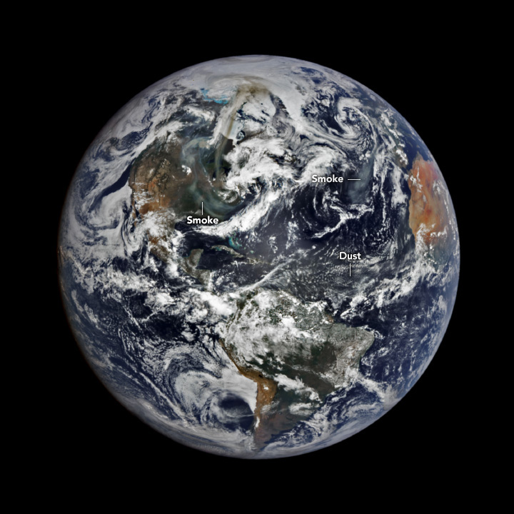
The EPIC wide view shows smoke from fires burning primarily in the Canadian provinces of Saskatchewan and Manitoba.
EDITOR'S NOTE: NASA is no longer allowed to attribute what have now become annual outbreaks of Canadian wildfires to climate change. Don't be too surprised if Trump decides to use this as another excuse to annex Canada so he can apply his theory that you can stop forest fires by raking the woods. - Will Collette
The plumes extend to
the north-northeast across Nunavut toward the coast of Greenland and southward
across the United States. Another patch of smoke is visible over the Atlantic
Ocean near Europe. Note that the hazy air west of Africa is not smoke but dust
that has blown westward from the Sahara Desert.
The blazes forced tens of thousands of people across three
provinces to evacuate. Around 5,000 evacuated from Flin Flon as a major blaze
crossed from Saskatchewan into Manitoba, according to news
reports. This fire, among many others, led officials to declare a state of
emergency in Saskatchewan and Manitoba in
late May.
Smoke from the fires burning in Canada has raised health concerns as airborne particles degraded air quality locally and in several U.S. states. In Michigan, officials issued an air quality advisory on May 30, noting that the air could become unhealthy for sensitive groups. On June 2, Minnesota issued an air quality alert, as particle pollution in the state’s northwest neared hazardous levels for all people.
The jet stream pulled smoke even farther south. The detailed
image above, acquired May 31 with the VIIRS (Visible
Infrared Imaging Radiometer Suite) on the NOAA-21 satellite,
shows smoke reaching northern Florida. Smoke-affected states farther from the
fires saw mostly good to moderate
air quality. Still, smoke high in the air can tint skies orange and
contribute to some striking sunsets.
Since the start of the year, 1,586 fires have burned more
than 1 million hectares across Canada, according to a report issued June 1 by
the Canadian Interagency Forest Fire Center. In 2024, the country saw 1,343
fires burn less than half a million hectares by the same date. Canada’s
wildfire season has historically run from late April to August, but fires can
happen any
time of the year.
Text by Kathryn Hansen.