Menu Bar

Home           Calendar           Topics          Just Charlestown          About Us
Showing posts with label ocean. Show all posts

Tuesday, July 28, 2026

Seaweeds are not plants – and six other surprising facts about aquatic flora

Crucial to life on earth

Alexander Bowles, University of Oxford

Hidden beneath the water’s surface is a botanical world that is among nature’s most innovative and ecologically important.

As I highlighted in a recent paper, an extraordinary range of adaptations have evolved in aquatic plants for life beneath the water’s surface. Some flower underwater, others capture animals in ingenious traps. Here are seven facts that show how these remarkable organisms challenge our assumptions about what plants are and how they survive.

Many people think of plants as nice-looking greens. Essential for clean air, yes, but simple organisms. A step change in research is shaking up the way scientists think about plants: they are far more complex and more like us than you might imagine. This blossoming field of science is too delightful to do it justice in one or two stories. This article is part of a series, Plant Curious, exploring scientific studies that challenge the way you view plantlife.

1. Plants can’t stop returning to water

When we think of plants, we often picture life on land: forests, grasslands and meadows. Yet throughout their evolutionary history, plants have repeatedly returned to the water, where they first evolved. Around 500 million years ago, plants moved from water onto land. Since then, many have moved back. Scientists estimate that the aquatic lifestyle has evolved independently more than 100 times across different plant groups.

Water lilies float their leaves on the surface, duckweeds drift freely and seagrasses live entirely submerged in the ocean. Some of these groups made their return over 100 million years ago. The repeated evolution of aquatic plants is one of nature’s most striking examples of convergent evolution.

Monday, July 27, 2026

How we got to have clam cakes and stuffies

Stanford Scientists Solve a 252-Million-Year-Old Mass Extinction Mystery

By Stanford University

Modern and Paleozoic Fauna
Representative samples of the modern fauna
(left three samples) and the Paleozoic fauna
(right four samples). Credit: Sarah Leibovitz

The shells scattered along modern beaches are clues to an ancient catastrophe. Clams and snails are common today partly because their distant relatives survived the worst mass extinction in Earth’s history, while many of their former rivals nearly vanished.

A new Stanford-led study helps explain why.

About 252 million years ago, the Permian-Triassic extinction event eliminated 96% of marine species and 70% of land animals. Known as the “Great Dying,” it was far more destructive than the later disaster that wiped out the non-avian dinosaurs.

Why Some Ocean Animals Vanished

Yet the crisis was not equally deadly for every branch of animal life. Some groups that had dominated the oceans for hundreds of millions of years suffered catastrophic losses, while others endured and eventually took their place.

Brachiopods were among the biggest casualties. These shelled animals resemble clams but belong to a completely different evolutionary group. Before the extinction, they were among the most abundant creatures on the seafloor. Crinoids, or sea lilies, and several other mostly stationary bottom dwellers also declined sharply.

Saturday, July 25, 2026

This looks like the perfect challenge for ICE

“Weird Clams” Reveal a New Invasion Along the U.S. Northeast Coast

By University of Massachusetts Amherst

Empty Manila Clam Shells
Empty Manila clam shells blanketing the
 intertidal zone in Boston Harbor’s Spectacle
Island. Credit: Aly Putnam

A stretch of Atlantic shoreline that had remained free of Manila clams now appears to support reproducing populations of the invasive shellfish.

Biologists led by the University of Massachusetts Amherst, MIT Sea Grant at the Massachusetts Institute of Technology and the Center for Coastal Studies confirmed that Ruditapes philippinarum has established itself along the northwestern Atlantic coast. Published in Biological Invasions, the findings capture a rarely documented stage of biological invasion, when a species is first becoming established and beginning to spread through a new region.

Manila clams are native to waters extending from Russia’s Sakhalin Islands through Japan and southern China. Since at least the early 20th century, however, people have introduced them both intentionally and accidentally to the Pacific coast of North America and to Europe, allowing the species to spread across much of the Northern Hemisphere.

The clams are widely valued as food and support an industry worth about $7 billion annually. At the same time, dense populations can compete with native shellfish, hybridize with related species, and alter surrounding ecological communities.

Carolina Bastidas in Squantum, Massachusetts
Co-author Bastidas in Squantum, Massachusetts,
holding a native quahog clam. Mussels and Manila
clams are visible in the tray. Credit: Carolina Bastidas

Their arrival may also bring some benefits. Manila clams can provide abundant food for seabirds, crabs, raccoons, and other animals that prey on shellfish.

“Given that Manila clams are everywhere else in the northern hemisphere, it was only a matter of time before they showed up here, and we’ve been keeping an eye out for them,” says marine scientist Aly Putnam, who is a postdoctoral researcher at UMass Amherst and lecturer at Smith College, as well as the paper’s lead author.

A text message starts the search

The Northeastern U.S. had represented the last major gap in the Manila clam’s Northern Hemisphere range. Evidence that the species had reached this coastline emerged from something remarkably ordinary: a text message.

During the summer of 2025, Putnam was leading a small workshop on intertidal biodiversity at Spectacle Island in Boston Harbor when El Fernekees Hartshorn sent her a photograph of an unfamiliar clam. Fernekees Hartshorn, a recent University of Rhode Island graduate who had worked with Putnam on regional Rapid Assessment Surveys for marine invasive species, suggested that the shellfish might be a Manila clam. Fernekees Hartshorn is also a co-author of the paper.

Tuesday, July 14, 2026

What could possibly go wrong?

Trump’s Push for Deep-Sea Mining 

By Gina-Marie Cheeseman

Minerals like nickel and cobalt are in so many of the products we use, including the device you’re reading this on. That demand is exactly what The Metals Company (TMC) is banking on. In March 2026, TMC joined the U.S. Defense Industrial Base Consortium (the “DIBC”). 

This Pentagon-managed body steers non-dilutive federal funding to critical minerals suppliers, pitching its deep-sea nickel, cobalt, and manganese as a domestic supply the government should help pay to develop.

The Metals Company has a problem. It cannot survive without governmental handouts. The company’s 2025 financial update reveals a net loss of roughly $319.8 million, $0.83 per share, on essentially no revenue. 

“If deep-sea mining is truly the next big thing its backers claim, why can’t The Metals Company attract investors — and why do they expect taxpayers to foot the bill? This isn’t about security; it’s about propping up a speculative industry that risks irreversible harm to the deep ocean for corporate profit,” said Jackie Dragon, Greenpeace USA Senior Oceans Campaigner

The push for deep-sea mining comes from the top. In April 2025, Trump signed an executive order to “accelerate the responsible development of seabed mineral resources.” In other words, he directed federal agencies to accelerate the development of deep-sea mining because the nation needs more critical minerals for its electronics. Trump’s proposed 2027 budget includes funding for critical minerals across the departments of Energy, Interior, Defense, and State.

Sunday, July 12, 2026

New Disease Threats Follow Trump Administration’s Health Program Cuts

How Trump and Musk cuts have led to increased danger

As beachgoers flock to water during the busy July Fourth weekend, danger could be lurking in some areas.

Researchers this spring discovered flesh-eating bacteria in water in several coastal locations across New York’s Long Island, and town officials in the Hamptons vacation destination posted an alert about the findings. Eight people in Florida have been infected this year, and Mississippi health officials in June urged people to take precautions.

About 1 in 5 people infected by the bacteria die, sometimes within a day or two of becoming ill, according to a Centers for Disease Control and Prevention fact sheet. The bacteria, Vibrio vulnificus, can enter open wounds and cause tissue death and systemic sepsis.

“Many people with Vibrio vulnificus infection can get seriously ill and need intensive care or limb amputation,” the CDC says.

The risk of such public threats is mounting because climate change is expanding the territory of certain pathogens, but researchers say there’s another concern. The Trump administration has cut investments in programs and agencies that prevent, track, and respond to health hazards the federal government is now confronting.

Consider the reemergence of screwworm, which can infest and kill livestock, in the U.S. in June. The U.S. Department of Agriculture lost 18% of its workforce in the first six months of 2025, according to a report from the USDA’s Office of Inspector General, and the agency’s winnowed-down inspection service is helping lead the response to the parasite.

Or malaria. A freeze on foreign aid disrupted international malaria prevention efforts, and new federal guidance in May warned that the U.S. is vulnerable to the reintroduction of the infectious disease.

And when it comes to Vibrio, the Trump administration began removing hundreds of deep-sea instruments that monitor ocean waters and yield data that helps predict conditions that can allow the bacteria to flourish. Researchers have used the data to study Vibrio, which can multiply rapidly when water temperatures and salinity increase.

Friday, June 5, 2026

Foulkes Unveils Third Component of “Believe in Rhode Island” Economic Plan: Creating & Growing Good-Paying Jobs

Proposes $150 Million Ocean Economy Investment Fund 

Helena Buonanno Foulkes shared the final part of her Believe in Rhode Island economic plan: creating good-paying jobs in Rhode Island. This plan lays out Helena’s vision to leverage Rhode Island’s unique assets that no other states can replicate: our talent and our location. 

“For too long, Rhode Island has been solving the wrong problem when it comes to our economic development strategy, and it’s driven away large employers and left our people behind. I’m excited to share the final part of my economic plan, centered around my belief in Rhode Island,” said Helena. 

“It’s time to lean into what sets Rhode Island apart from other states: our people, our colleges and universities, our world-class food and arts scene, and our 400 miles of coastline and access to the ocean. As governor, I’m going to bet on our people and lean into our strengths, and I’m excited to grow our economy together.” 

Part Three of Helena’s Believe in Rhode Island Plan includes:

Tuesday, June 2, 2026

Chinese researchers pick up climate research the US has abandoned

Scientists Just Confirmed What’s Driving Sea Level Rise And It’s Alarming

By Institute of Atmospheric Physics, Chinese Academy of Sciences

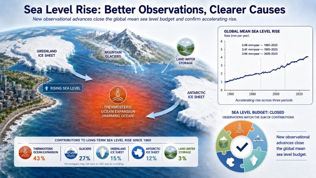
Causes of Sea Level Rise InfographicCauses of global mean sea level rise since 1960. Credit: Zheng et al., Science Advances (2026)

Sea level rise is one of the most visible consequences of human-driven climate change. As the planet warms, oceans absorb heat and expand, while melting glaciers and giant ice sheets add increasing amounts of water to the seas. Scientists say the process is persistent, difficult to reverse, and likely to continue for centuries.

A new international study has now provided the clearest explanation yet for what has been driving global sea level rise over the past 60 years. The research also resolves a long-standing discrepancy that had left scientists unable to fully account for all observed ocean rise.

Sea Level Rise Is Accelerating Worldwide

The study, published in Science Advances and led by researchers in China, found that global sea levels have risen by an average of 2.06 millimeters per year since 1960. More concerning, the pace has accelerated sharply in recent decades, climbing to 3.94 millimeters per year between 2005 and 2023.

Researchers determined that ocean warming is the single largest contributor, responsible for 43% of total sea level rise since 1960. When seawater heats up, it expands and occupies more space, causing ocean levels to increase even without adding extra water.

Friday, May 22, 2026

Marine life finds new home at base of wind turbines

How sea critters and wind turbines co-exist

URI Ph.D. student Emmanuel Oyewole
conducting field work at the South Fork
Wind farm turbines.
(Photos courtesy Emmanuel Oyewole)

As lobsters migrate to colder waters due to climate change, Jonah crabs are becoming one of the most important species for fisheries in Southern New England.

“As the biomass of the American lobster declines due to climate-related changes and shifting ocean conditions, many fishermen have adapted by targeting other valuable species, and the Jonah crab has become a major alternative,” said Emmanuel Oyewole, a first-year Ph.D. student in the University of Rhode Island’s Graduate School of Oceanography

“The Jonah crab used to be considered a bycatch species and thrown back because lobster was so lucrative. As lobsters became less abundant, people started to realize that the Jonah crab is a viable and delicious alternative.”

Oyewole is conducting a study that is partly funded by a grant from The Nature Conservancy into how offshore wind farm structures are impacting the growth and habitats of Jonah crabs.

Oyewole prepares Jonah crab muscle samples for analysis in URI’s Ocean Ecogeochemistry Laboratory.

“Ecologically, Jonah crabs also play an important role in the marine food web,” said Oyewole, who is from Ilé-Ifẹ̀, Nigeria, a town in the southwestern part of the country. “They are both predators and prey, helping to maintain balance within benthic ecosystems. Because they are closely connected to seafloor habitats, they can help us understand how offshore wind farm structures may influence local biodiversity, habitat use, and the productivity of fisheries.”

When turbine foundations are installed on the seafloor, their hard surfaces become desirable habitats for marine organisms to attach, grow, and live, just as they do on natural rock or reefs. As algae, barnacles, mussels, and other small marine life, settle on these structures, these smaller organisms attract larger species such as crabs and fish that come to feed, hide, or seek shelter.

“The turbines can create a kind of ‘mini ecosystem.’ They provide food and habitat, which can draw marine life into the area and potentially change how species use the surrounding environment,” said Oyewole. “The question is whether they are increasing the overall amount of marine life in the ocean by creating new production or simply concentrating animals that were already living in the surrounding areas.”

The data Oyewole collects and analyzes will benefit the Commercial Fisheries Research Foundation, a nonprofit organization founded by local commercial fishermen.

Thursday, May 21, 2026

Scientists are reading Block Island’s past to protect its future

Maybe it will teach us more about coastal change

By Amber Neville

Two new URI studies will decode over a century of coastal change on one of New England’s most treasured islands, delivering planning tools and scientific guidance directly to the community, backed by more than $800,000 in combined Rhode Island Sea Grant funding and matching funds. (URI Photo / Rhode Island Sea Grant)

Every summer, the population of Block Island swells to over 15,000 as visitors arrive for its 17 miles of beaches, dramatic glacial bluffs, and quiet ponds. The island has always changed — its bluffs eroding, its shorelines shifting, its marshes responding to the rhythms of tide and season. But the pace of that change is accelerating, and the decisions the community makes in the coming years will shape what the island looks like for generations to come.

The University of Rhode Island is working alongside that community to make those decisions better informed. Two new research projects, supported by more than $800,000 in combined Rhode Island Sea Grant funding and matching funds from URI and Eastern Connecticut State University (ECSU), will produce the most detailed picture yet of how Block Island’s shoreline and salt marshes are changing and what is driving those changes.

Wednesday, April 29, 2026

Managed Retreat Can be an Opportunity to Start Fresh

Sooner or later, the ocean will win

By Rep. Terri Cortvriend and Sen. Victoria Gu / R.I. General Assembly

No matter how rich you are, you can't stop the ocean
In 2023, our state took a big step to enshrine Rhode Islanders’ right to the shoreline: up to 10 feet above the last high-tide line. But what happens as sea level rise pushes the high-tide line up to homeowners’ and businesses’ seawalls?

Our beaches and shoreline are fragile ecosystems that naturally migrate upland as sea levels rise. But as homeowners and businesses increasingly put up rock walls and fortify their property, the beach has nowhere to go. When that sandy beach disappears, there goes one of our greatest natural assets, and the tourism economy on which Rhode Island’s economy relies erodes along with it.

Bottom of Form

Even seawalls, however, are not a permanent defense for property in some places as sea levels rise and storm severity and frequency continue to grow. On our coast and inland, several neighborhoods — most recently some along the Pocasset River in Cranston and Johnston — in our state have experienced such severe and frequent flooding that they qualified for federal funding for buyouts. In those situations, both the government and the property owners agree that the dangers and costs of continuing to live in those areas are simply too high.

Planning to prevent disaster, however, is always safer and less costly than responding to it.

“Managed retreat” is a planned effort to identify disaster-prone areas and relocate homes, businesses, and infrastructure there to safer places before they are destroyed.

Managed retreat can often protect other areas nearby, since the removal of human-made structures can help reduce erosion and flooding, and the restored area becomes a natural place for water to go.

New satellite-based AI approach reveals ocean currents in unprecedented detail

A good use for AI?

Peter J. Hanlon 

GOFLOW temperature gradient computed in the Gulf Stream region in the Atlantic Ocean. (Credit: Luc Lenain/Scripps Institution of Oceanography)

A new study published in the journal Nature Geoscience describes an artificial intelligence-powered technique that can measure ocean surface currents over broad areas in greater detail than ever before. Among the co-authors is Nick Pizzo of the University of Rhode Island Graduate School of Oceanography.

Called GOFLOW (Geostationary Ocean Flow), the approach uses AI to analyze thermal images from weather satellites already in orbit. Because it relies on existing satellites, no new hardware is needed, marking what researchers describe as a major advancement in ocean observation.

A side-by-side comparison of ocean surface velocity and vorticity fields in the same region, showing GOFLOW (a) alongside AVISO (b). While the AVISO map is built from a 10-day average, the GOFLOW map is built from hourly data, revealing greater detail. (Credit: Luc Lenain/Scripps Institution of Oceanography)

The study was co-led by Luc Lenain of Scripps Institution of Oceanography at University of California San Diego and Kaushik Srinivasan of University of California, Los Angeles. Co-author Roy Barkan of Tel Aviv University and Pizzo are also alumni of Scripps. The project was supported by grants from the Office of Naval Research, NASA, and the European Research Council.

Tuesday, April 21, 2026

Trump’s Budget Proposes Massive Cuts for Climate and Environmental Programs

The budgets of the EPA, NOAA and FEMA would all be slashed, as would incentives for renewable energy.

This article originally appeared on Inside Climate News, a nonprofit, non-partisan news organization that covers climate, energy and the environment. Sign up for their newsletter here.

Donald Trump’s annual budget request to Congress continues his administration’s defunding of climate change programs, environmental protection and renewable energy, slashing the budgets of the Environmental Protection Agency, the National Oceanic and Atmospheric Administration and the Federal Emergency Management Agency. 

The spending plan for fiscal 2027 “builds on the President’s vision by continuing to constrain non-defense spending,” wrote Russell Vought, director of the Office of Management and Budget, in a foreword to the 92-page document, which includes an historic, $1.5 trillion defense budget, an increase of 44 percent.

EPA spending would be cut in half under Trump’s proposal, released Friday, and grants from the agency would be slashed by $1 billion. Congress rejected a similar budget request from the president last year. 

An Inside Climate News analysis of federal workforce data released by the Office of Personnel Management shows that EPA lost more than 4,000 employees in the first year of Trump’s second term, reducing its workforce to 12,849, its lowest level since the 1980s. The 24 percent reduction was more than double the rate of losses across the entire federal government.

Thursday, April 2, 2026

Scientists solved the mystery of missing ocean plastic—and the answer is alarming

The plastic didn’t disappear—it went invisible and spread everywhere.

Royal Netherlands Institute for Sea Research


Scientists have uncovered something surprising in the Atlantic Ocean. The majority of plastic pollution may no longer be visible at all. Instead, it exists as nanoplastics, particles so small they are measured in billionths of a meter.

"This estimate shows that there is more plastic in the form of nanoparticles floating in this part of the ocean than there is in larger micro- or macroplastics floating in the Atlantic or even all the world's oceans!" said Helge Niemann, researcher at NIOZ and professor of geochemistry at Utrecht University. In mid-June, he received a 3.5 million euro grant to further investigate nanoplastics and what ultimately happens to them.

Ocean Expedition Reveals Tiny Plastic Particles

To gather data, Utrecht master's student Sophie ten Hietbrink spent four weeks aboard the research vessel RV Pelagia. The ship traveled from the Azores to the European continental shelf, where she collected water samples at 12 different locations.

Each sample was carefully filtered to remove anything larger than one micrometer. What remained contained the smallest particles. "By drying and heating the remaining material, we were able to measure the characteristic molecules of different types of plastics in the Utrecht laboratory, using mass spectrometry," Ten Hietbrink explains.

First Real Estimate of Ocean Nanoplastics

Previous studies had confirmed that nanoplastics existed in ocean water, but no one had been able to calculate how much was actually there. This research marks the first time scientists have produced a meaningful estimate.

Niemann notes that this breakthrough was made possible by combining ocean research with expertise from atmospheric science, including contributions from Utrecht University scientist Dusân Materic.

27 Million Tons of Invisible Plastic

When the team scaled their measurements across the North Atlantic, the results were striking. They estimate that about 27 million tons of nanoplastics are floating in this region alone.

"A shocking amount," Ten Hietbrink says. The finding may finally explain a long-standing mystery. Scientists have struggled to account for all the plastic ever produced. Much of it appeared to be missing. This study suggests that a large share has broken down into tiny particles that are now suspended throughout the ocean.

Sunday, December 21, 2025

Hundreds of Sea Turtles Are Freezing in Cape Cod

Add this to climate change's tab

This article originally appeared on Inside Climate News, a nonprofit, non-partisan news organization that covers climate, energy and the environment. Sign up for their newsletter here.

Over the last few weeks, volunteers have braved bitter winds and freezing temperatures to patrol Cape Cod’s bayside beaches at night, sweeping their flashlight beams along the last high-tide line marked with mounds of seaweed, searching for signs of life.

“That’s where you’re most likely to find a turtle,” said Mark Faherty, science coordinator at Mass Audubon’s Wellfleet Bay Wildlife Sanctuary, which runs a sea turtle rescue and research program in Cape Cod. 

Every year, from November through early January, hundreds of juvenile sea turtles strand on these beaches when water temperatures drop below 50 degrees Fahrenheit, leaving them cold-stunned—a hypothermic reaction experienced by marine reptiles—and unable to swim. 

Disoriented and helpless, the animals drift until the surf deposits them on the beach, covered in algae and barnacles, so still and so camouflaged they often resemble rocks. Kemp’s ridleys—the world’s most endangered sea turtle—make up the majority, along with smaller numbers of green and loggerhead turtles.

Monday, October 27, 2025

URI looking for fresh water UNDER the ocean

Multi-National Effort to Study Fresh Water Found Beneath Ocean off New England

By Bonnie Phillips / ecoRI News staff

A few women wearing hard hats and holding a computer

AI-generated content may be incorrect.
British Geological Survey hydrogeologist Rachel Bell, left,
discusses groundwater sampling logistics in front of the sampling
manifold with Expedition 501 co-chief scientist Rebecca Robinson
 of URI. (Maryalice Yakutchik/ECORD IODP³)

On May 19, the L/B Robert chugged out of Bridgeport, Conn., heading to an area of the Atlantic Ocean off the island of Nantucket.

The Robert isn’t a fishing boat, or at least the kind that brings back fish, crabs or lobster.

This expedition was fishing for water. Fresh water. Under the ocean.

How can that be, you ask? How can fresh water be underneath the ocean floor? And how did it get there?

Rebecca Robinson, a professor of oceanography at the University of Rhode Island’s Graduate School of Oceanography, is attempting to answer those questions.

Robinson was one of three chief scientists leading the multi-national team of 41 researchers on the first-of-its-kind New England Shelf Hydrogeology expedition aboard the Robert to study water and sediment samples taken from up to three locations beneath the ocean on the New England Shelf.

After 74 days offshore, the team returned in August with 718 core samples to be analyzed in the expedition’s researchers’ respective labs.

“Sampling of this offshore freshened groundwater to the extent that we can make comprehensive geochemical assessments of its history, including its age, is unprecedented in scientific ocean drilling,” said Robinson, who is also an associate director of URI’s Coastal Institute.

Sunday, October 26, 2025

Public pushback forces Coast Guard to drop plan to remove navigational buoys

U.S. Coast Guard suspends buoy removal plan after public concern

By Nancy Lavin, Rhode Island Current

The U.S. Coast Guard has cast off plans to remove hundreds of navigational buoys from the Northeast, including in Rhode Island.

The federal maritime agency announced Tuesday it was pausing its buoy modernization plan in light of the more than 3,200 public comments received.

“The Coast Guard will be conducting further analysis of the aids to navigation (ATON) system,” the agency said in a statement posted to its website. “There will be no changes to ATON in relation to the proposal until further analysis is complete.”

The update comes a month after the Coast Guard scaled back its initial plan due to concern from local mariners. Originally, the federal agency proposed removing 350 of the oldest buoys from regional waterways, including 37 in Rhode Island. The Coast Guard then amended its plans to take out 233 buoys, including 20 in Rhode Island.

The revised plan also reopened the public comment period through Nov. 15. But with the plan now suspended, the public comment period is closing early, the Coast Guard said. 

The Coast Guard billed the removal of navigational markers as an embrace of modern technology, targeting the oldest buoys that were put in place before modern GPS systems. But mariners, environmental groups and lawmakers, including U.S. Sen Jack Reed, argued the cuts could compromise safety for boaters who rely on the markers in bad weather, and when GPS systems are unavailable.

Reed praised the Coast Guard for taking heed of concerns on Wednesday. 

Saturday, September 20, 2025

A monster seaweed bloom is taking over the Atlantic

Seaweed: threat or menace?

Florida Atlantic University

US Fish and Wildlife Service
Researchers at Florida Atlantic University's Harbor Branch Oceanographic Institute have released a landmark review tracing four decades of changes in pelagic sargassum - free-floating brown seaweed that plays a vital role in the Atlantic Ocean ecosystem.

Once thought to be primarily confined to the nutrient-poor waters of the Sargasso Sea, sargassum is now recognized as a rapidly growing and widely distributed marine organism, whose expansion across the Atlantic is closely linked to both natural processes and human-induced nutrient enrichment.

The review, published in the journal Harmful Algae, sheds new light on the origins and development of the Great Atlantic Sargassum Belt, a massive recurring bloom of sargassum that stretches across the Atlantic Ocean from the coast of West Africa to the Gulf of America.

Since its first appearance in 2011, this belt has formed nearly every year - except in 2013 - and in May, reached a new record biomass of 37.5 million tons. This does not include the baseline biomass of 7.3 million tons historically estimated in the Sargasso Sea.

By combining historical oceanographic observations, modern satellite imagery, and advanced biogeochemical analyses, this review provides a comprehensive framework for understanding the dramatic changes in sargassum distribution, productivity and nutrient dynamics. It also highlights the broader implications of anthropogenic nutrient enrichment on ocean ecology and the need for coordinated international efforts to monitor and manage the impacts of these massive seaweed blooms.

Tuesday, September 16, 2025

Block Island and University of Rhode Island partner to strengthen coastal resilience

Long-term partnership to protect land, water, and livelihoods

By Amber Neville, URI Coastal Institute

A lifeguard stand on a beach

AI-generated content may be incorrect.
Protective fencing on Block Island safeguards dune vegetation, a natural
barrier against coastal erosion. (URI Photos/Coastal Institute)

The University of Rhode Island Coastal Institute has officially designated Block Island as its newest Climate Response Demonstration Site (CRDS), formalizing a partnership to protect the island’s natural systems, infrastructure, and freshwater resources. The New Shoreham Town Council voted unanimously in support of the designation on July 7, following a recommendation from the town’s Coastal Resilience Committee.

Block Island joins a growing network of CRDS sites across Rhode Island—places where science, policy, and community priorities come together. Each site serves as a model for resilience, showcasing place-based strategies tailored to the distinct challenges and strengths of its location.

Wednesday, July 23, 2025

Rhode Island funds key storm tools hurt by Trump/MAGA budget cuts

URI programs secure state funding for CHAMP, StormTools, and MyCoast, to continue providing critical services for Rhode Island

Kristen Curry

In the past, hurricanes hit the Rhode Island coastline without warning;
now RI-CHAMP provides early-warning alerts to state
emergency managers on coastal flooding and wind impacts
caused by hurricanes and nor’easters, giving coastal
communities critical time to prepare. (Coastal Resources Center)
EDITOR'S NOTE: GoLocal reports the Trump regime has also wiped out funding for beach restoration, forcing the state and towns to come up with cash to carry on the work. Similarly, GoLocal notes how Charlestown is trying to get state funds for more permanent repairs to the Charlestown Breachway after federal funds were denied. Thank you, MAGA.   - Will Collette

Rhode Island legislators have endorsed a powerful complement of tools developed and housed at the University of Rhode Island so they can continue to benefit the state coastline and residents, approving $200,000 in the 2026 fiscal year budget. Legislators and researchers say that support to keep URI’s critical CHAMP, STORMTOOLS, and MyCoast programs going demonstrates that URI, and Rhode Island, will continue to lead in coastal safety analysis, early warnings, and resilience.

Bringing together URI’s Coastal Resources Center, Rhode Island Sea Grant, Graduate School of Oceanography,  Environmental Data Center, and the departments of Marine Affairs and Ocean Engineering, a successful team drawing on the best of URI, the tools were developed and launched to respond to the needs of Rhode Island’s emergency managers, partner communities, state regulatory agencies, and military, to plan for and respond to storms and associated flooding.

“We’ve been working together on these projects for 10 years,” says Austin Becker, chair of URI’s Department of Marine Affairs and director of URI’s graduate certificate in Coastal Resilience, “and the collaboration has been truly wonderful.”

Funding for research and development came from the Department of Homeland Security, the Federal Emergency Management Agency, Department of Defense, and numerous other sources. In the years since, URI has dedicated significant expertise and resources to develop the powerful suite of tools, which play key roles in addressing coastal storm risks.

The Rhode Island state funding affirms support in the Ocean State for technology and tools that prepare for weather impact in advance.

“This is a huge win,” says Becker. “This will allow us to keep these tools in operation, supporting the climate resilience needs of Rhode Island. It’s gratifying to see the state recognize the value of this work to municipalities and agencies from the Coastal Resources Management Council (CRMC) and Rhode Island Emergency Management Agency to the Department of Environmental Management and Department of Health.”

As federal funding priorities changed, Rhode Island pivoted to maintain support for these critical emergency preparation and management tools, as support from community users demonstrated the value of the tools.

The initial bill was sponsored by Rhode Island Rep. Terri Cortvriend (Middletown, Portsmouth), who first came to Rhode Island as a boat captain. She founded a marine plumbing firm here and is familiar with coastal issues as a member of the state’s marine trade association, but says she advocated for the provision out of concern over seeing Rhode Island lose funding for these critical decision support tools.

Introducing the measure, Cortvriend asked her peers to join her in supporting Rhode Island’s homegrown coastal resilience technologies. “As we face increasing risks to our population due to more frequent and severe storms,” she said, “it is imperative that we equip our decision-makers and emergency managers with the tools necessary to mitigate impacts, enhance recovery, and reduce both human suffering and economic losses. These tools provide crucial data and predictions for emergency management, resilience planning, and community engagement across our state.”

Stephen McCandless M.S. ’21, GIS coordinator for the town of Charlestown, said the tools are essential for emergency management, planning, and coastal policy work in Rhode Island.

“These tools have proven indispensable in our ability to manage and prepare for coastal hazards,” he said. “We rely on them regularly in our operations.”

Saturday, July 19, 2025

Study reveals for the first time the extent to which nanoplastic pollutes the North Atlantic

Underestimated sources of marine pollution

Helmholtz Centre for Environmental Research

Plastic particles less than one micrometer in size are found across the globe – from the peaks of the Alps to the depths of the oceans. A research team from the Helmholtz Centre for Environmental Research (UFZ), Utrecht University, and the Royal Netherlands Institute for Sea Research (NIOZ) investigated the presence of nanoplastic in the North Atlantic. 

The findings show that nanosized plastic particles are present at all depths between the temperate and subtropical zone of the ocean. By mass, the amount of nanoplastic is comparable to that of microplastic. An article published in Nature concludes that nanoplastic plays a far greater role in marine plastic pollution than previously assumed.

Plastic waste pollutes oceans across all regions of the world. Marine animals may become entangled in larger plastic debris such as nets and bags or mistake smaller pieces for food. Ingested plastic can block or injure the gastrointestinal tract. The smallest plastic particles in the micro and nano range are mostly excreted, but a small proportion can pass through the intestinal wall and enter the bloodstream.