To watch this video on YouTube: https://www.youtube.com/watch?v=xkxEw3sfzPo
Saturday, June 30, 2018
Call to action on the Supreme Court
To watch this video on YouTube: https://www.youtube.com/watch?v=xkxEw3sfzPo

DEM offers tips on dealing with beach traffic
Beach Season In
Full Swing
 With
Independence Day and the peak of the beach season fast approaching, the
Department of Environmental Management (DEM) is encouraging beach-goers to buy
seasonal passes today to help ease traffic tie-ups this weekend and on the
Fourth of July.
With
Independence Day and the peak of the beach season fast approaching, the
Department of Environmental Management (DEM) is encouraging beach-goers to buy
seasonal passes today to help ease traffic tie-ups this weekend and on the
Fourth of July.
Temperatures are
expected to soar into the 90s tomorrow and Sunday, bringing the potential for
large crowds and traffic backups at our beaches. DEM offers the following tips
to ease traffic lines at the entrance booths:
1. Have Payment and Vehicle Registration
Ready.
Nobody likes waiting, especially on a hot sticky day. But you can speed things up – for yourself and the people behind you – by having your cash or credit card and your vehicle registration ready when you reach the entrance booth. Your registration is not your license. It includes your vehicle identification number, registration fee, license plate number, and home address. (Most likely, it's in the glove compartment along with your proof of insurance and related information.) By regulation, DEM relies only on vehicle registration to administer parking fees.
Nobody likes waiting, especially on a hot sticky day. But you can speed things up – for yourself and the people behind you – by having your cash or credit card and your vehicle registration ready when you reach the entrance booth. Your registration is not your license. It includes your vehicle identification number, registration fee, license plate number, and home address. (Most likely, it's in the glove compartment along with your proof of insurance and related information.) By regulation, DEM relies only on vehicle registration to administer parking fees.
Mystic Aquarium announces events and activities for July
Special Conservation-Themed Programming Offers Family-Friendly Fun
 During the month of July, Mystic Aquarium’s
conservation events are all about Nature Play Programming.
During the month of July, Mystic Aquarium’s
conservation events are all about Nature Play Programming.
The Aquarium’s conservation-focused programs are designed to inform guests about the importance of preserving and protecting the environment through fun and engaging outdoor experiences.
 During the month of July, Mystic Aquarium’s
conservation events are all about Nature Play Programming.
During the month of July, Mystic Aquarium’s
conservation events are all about Nature Play Programming. The Aquarium’s conservation-focused programs are designed to inform guests about the importance of preserving and protecting the environment through fun and engaging outdoor experiences.
The outdoor family fun kicks-off on Tuesday, July 3
with a Nature Play Aquarium Camp Out.
The overnight adventure starts at 7:00 pm and wraps up the following morning at 9:00 am. Participating families will have the unique opportunity to explore the Aquarium at night.
The overnight adventure starts at 7:00 pm and wraps up the following morning at 9:00 am. Participating families will have the unique opportunity to explore the Aquarium at night.
URI receives $3 million grant to study disease that often co-exists with Alzheimer’s
Going after a related disease that adds to dementia and brain bleeds
 A $3.3 million grant from the National Institutes of
Health will support a University of Rhode Island neuroscientist’s research to
identify early-stage biomarkers for a brain disease often found to coexist with
Alzheimer’s disease.
A $3.3 million grant from the National Institutes of
Health will support a University of Rhode Island neuroscientist’s research to
identify early-stage biomarkers for a brain disease often found to coexist with
Alzheimer’s disease.
The
five-year grant was awarded to William Van Nostrand, Hermann Professor of
Neuroscience at URI’s George & Anne Ryan Institute for Neuroscience.
The funding will help fill a critical research niche in early detection of cerebral amyloid angiopathy, a disease in which amyloid deposits form in small and medium blood vessels in the central nervous system, contributing to dementia and brain hemorrhages.
Although the disease is common in the elderly, it often isn’t diagnosed until its late stages, when bleeds can be detected by brain imaging.
Unremarkable year for environmental progress
By TIM FAULKNER/ecoRI News staff
 The 2018 General Assembly
session was by all accounts unremarkable for environmental progress. There was
no major legislation passed related to climate change, energy, food, waste
reduction, or environmental justice.
The 2018 General Assembly
session was by all accounts unremarkable for environmental progress. There was
no major legislation passed related to climate change, energy, food, waste
reduction, or environmental justice.
One major success for animal
rights activists was the passage of limitations on
the use of restrictive wire cages, known as battery cages.
The devises confine egg-laying chickens for their entire lives without room to spread their wings, perch and perform other instinctive behaviors. The rule does not take effect until 2026.
The devises confine egg-laying chickens for their entire lives without room to spread their wings, perch and perform other instinctive behaviors. The rule does not take effect until 2026.
Rep. Art Handy, chairman of
the House Committee on Energy and the Environment, described the session as “slow”
for environmental bills. Many of the wide-ranging bills needed amendments to
get out of committee, like his energy-efficiency bill, but time simply ran out.
“Some (bills) should have
had a better shot,” Handy said.
Sweeping bills never made it
out of committee, such as a carbon-fee-and-dividend program and the Global
Warming Solutions Act, which makes carbon emission targets
enforceable.
Handy singled out the $48.5
million Green Economy and
Clean Water Bond referendum as a highlight of the year. Article
5 on the November ballot offers $5 million for coastal climate resiliency, $5
million for bike paths, and $4 million for open space and farmland protection.
Other bills
Friday, June 29, 2018
Getting the specifics on what climate change will do to us
By FRANK CARINI/ecoRI News staff
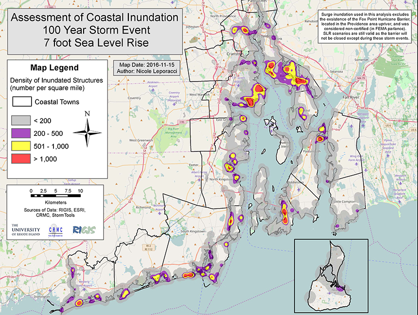
The Ocean State's 21 coastal communities have many structures that will be exposed to projected sea-level rise. (Beach SAMP)
When it comes to addressing the profound challenges presented by the Earth’s warming atmosphere, three words — “adaptation,” “mitigation” and “resilience” — are frequently deployed. But what do these buzzwords actually mean when it comes to addressing global warming in Rhode Island?
First, let’s define each of
the words.
Adaptation: “Adjustment
or preparation of natural or human systems to a new or changing environment
which moderates harm or exploits beneficial opportunities,” Environmental
Protection Agency.
Mitigation: “Processes
that can reduce the amount and speed of future climate change by reducing
emissions of heat-trapping gases or removing them from the atmosphere,” U.S. Climate Resilience Toolkit.
Resilience: “A
framework and principles to ensure that investments in climate change
adaptation are scientifically sound, socially just, fiscally sensible, and
adequately ambitious,” Union
of Concerned Scientists.
These words are used so
often and interchangeably — agencies even use the terms differently — that
their meanings have been diminished, as if simply uttering them addresses the
many challenges presented by climate change.
Grover Fugate, executive
director of Rhode Island’s Coastal
Resources Management Council (CRMC), calls resilience “the most
abused word in the English language. In the classic sense, it means the system
is robust enough to bounce back.”
In this era when we are
witnessing the climate change in mere decades instead of thousands of years,
thanks to building concentrations of atmospheric greenhouse gases, a bounce
back likely isn't in the cards. The system is closing in on collapse.
“We need to work toward mitigating
the effects of climate change so our children and grandchildren have a livable
world. The future depends on our behavior now,” said James Boyd, a CRMC coastal
policy analyst.
“The climate-change naysayers say we can fix this with carbon sequestration. They’re against zero-carbon energy. They want to use fossil fuels. The Earth is warming but we can fix that. We can’t. We can only slow it down. Even if we stopped carbon emissions today, sea-level rise is already baked into the system.”
“The climate-change naysayers say we can fix this with carbon sequestration. They’re against zero-carbon energy. They want to use fossil fuels. The Earth is warming but we can fix that. We can’t. We can only slow it down. Even if we stopped carbon emissions today, sea-level rise is already baked into the system.”

This chart and the one below are from Chapter 4 of the Beach SAMP.
A 2017
assessment from the National Oceanic and Atmospheric
Administration projects the baking to rise the waters off Rhode Island by 9.6
feet by 2100. By 2200, local sea-level rise is projected to be 32 feet.
As the ice sheets of the Arctic, Antarctic and Greenland disappear, this melt water won’t be uniformly distributed across the globe; the coasts of North America will be left to deal with much of it, for various scientific reasons, according to Fugate.
As the ice sheets of the Arctic, Antarctic and Greenland disappear, this melt water won’t be uniformly distributed across the globe; the coasts of North America will be left to deal with much of it, for various scientific reasons, according to Fugate.
Downtown Providence and
Wickford village in North Kingstown are at risk of significant damage from 3
feet of sea-level rise. Coastal roads in Narragansett and Jamestown are at risk
of being underwater with a foot of sea-level rise.
On Aquidneck Island, sea
level-rise maps of Newport’s waterfront, the heart of a thriving tourist
economy, reveal large swaths of harbor-side neighborhoods inundated and
prominent waterside landmarks partially submerged, all within an enlarged
harbor created by an additional 5 feet of sea. The Island Park neighborhood in
Portsmouth is among the most vulnerable areas in the state to storm surge and
sea-level rise.

Statewide, about $4.5 billion worth of property lies on land less than 5 feet above the high-tide line, and in Newport, for example, there is a 33 percent chance of a flood that high by 2040.
Rising seas also generate saltwater intrusion that can contaminate drinking-water supplies and private wells, damage septic systems, reduce the lifespan of asphalt, and threaten freshwater wetlands.
CRMC, a Wakefield-based
management agency with regulatory functions and a staff that includes coastal
geologists and engineers, is one of the leading agencies in the country when it
comes to addressing global warming. The agency has developed a number of
climate-change tools that model, project and educate, such as STORMTOOLS and Sea Level Affecting
Marshes Model (SLAMM).
The agency’s three special area management plans — Ocean SAMP, Beach SAMP and the still-in-development Metro Bay SAMP — are among a select few tools of their kind available to tackle climate-change issues. (California has a management plan that deals with sea-level rise.)
The U.S. Virgin Islands, New
Hampshire and California have all reached out to Fugate and CRMC to ask for
assistance in creating climate-change maps and tools.
ecoRI News recently met with
Fugate and Boyd to discuss Rhode Island’s climate-change challenges and how the
aforementioned climate strategies are and should be used to address local
problems.
Climate Adaptation
The Ocean State has about
420 miles of coastline that extends inland to include multiple waterways, most
notably Narragansett Bay. Shoreline types along the bay include vegetative
buffers and salt marshes, riprap, bulkhead and other hardened structures.
The bay’s shoreline also features disturbed areas, preserved marshland, post-industrial fill and polluting businesses. The bay’s working waterfront includes sites that store hazardous materials.
The bay’s shoreline also features disturbed areas, preserved marshland, post-industrial fill and polluting businesses. The bay’s working waterfront includes sites that store hazardous materials.
Sea-level rise, storm surge
and upland flooding in the Narragansett Bay watershed pose a considerable risk to
coastal municipalities along the bay, most notably Providence, Warwick, Warren
and Barrington.
“Amplification pushes surge
up into the bay where there’s less area for this water to go,” Fugate
explained. “Water is funneled up the bay.”

Rhode Island is part of an accelerated sea level-rise 'hot spot.'
(Beach SAMP Chapter 2)
He said sea-level rise of
5-7 feet would cover Providence’s downtown financial district and the Port of
Providence in water. This projected soggy future for downtown and ProvPort
doesn’t even take storm surge into consideration.
“The hurricane barrier is
not designed to protect the city from sea-level rise,” Fugate said. “It’s
designed to protect it from storm surge.”
Closed or open, sea-level
rise or storm surge, the Fox
Point Hurricane Protection Barrier does nothing to protect the
neighborhoods of South Providence and Washington Park from the toxins,
chemicals and pollutants buried in the dirt and hidden in the asphalt and
concrete of the city’s working waterfront.
The Port of Providence
serves as a coal port, a fuel-oil depot, and a train depot for ethanol. It’s
also home to several chemical-processing plants, including a facility that
manufactures chemicals for hydraulic fracturing.
The area proposed for a
second waterfront LNG facility is heavily contaminated. The 42-acre site on the
Providence River has endured more than a century of pollution. It once hosted
an Army rifle range, a coal gasification plant, and propane and kerosene
storage facilities.
Should this area be flooded
by sea-level rise or storm surge associated with a hurricane like the one Rhode
Island witnessed in 1954 — a 100-year event, according to Fugate, meaning it
has a 1 percent chance of happening annually — or 1938, a 250-year event, those
two neighborhoods would be soaked with some serious
nastiness.
Not all of the Ocean State’s
21 coastal communities, however, are along the shores of Narragansett Bay.
Many, such as Charlestown, Narragansett and Westerly, are on the open ocean and that presents a different set of climate-change problems, like accelerating erosion.
For instance, along the state’s more exposed southern shoreline in communities from Point Judith to Watch Hill, Matunuck, Misquamicut and South Kingstown Town Beach have lost some 400 feet of beach combined during the past four decades.
Charlestown Town Beach has
lost about 150 feet to erosion since 1939. Two of Rhode Island’s more popular
tourist destinations, Easton’s Beach in Newport and Sachuest Beach in
Middletown, are losing about a foot of shoreline annually.
Saltwater marshes, nature’s
protector against storm surge, are already drowning.

Percent chance of flooding for a given return period and a given
number of years. (Beach SAMP Chapter 3)
If someone were to buy a waterfront home in Rhode Island today with a typical 30-year mortgage, there is a 26 percent chance a 100-year storm would hit during the life of that mortgage.
The damage caused in fall
2012 by Sandy highlighted the vulnerability of the state’s coastal areas to the
effects of worsening storms and a changing climate.
When Sandy hit Rhode Island
in late October, it was barely a tropical storm, but it hung around for so long
that it caused big problems. Sandy’s storm surge was 5 feet lower than that of
the 1938 hurricane, but it still caused a lot of damage — an estimated $42
million in Rhode Island recovery costs.
The so-called superstorm
stripped some 1,600 tons of sand from Narragansett Town Beach and dumped about
18,000 tons onto Atlantic Avenue in Westerly.
In Charlestown, more than 4 feet of sand wound up on Charlestown Beach Road. Storm waves tossed boulders around like beach balls along the Charlestown Breachway.
In Charlestown, more than 4 feet of sand wound up on Charlestown Beach Road. Storm waves tossed boulders around like beach balls along the Charlestown Breachway.
In all, the Ocean State lost
about 90,000 cubic yards of beach sand because of Sandy’s rude visit.
As the burning of fossil
fuels continue to warm the oceans, Rhode Island will experience a growing
number of more intense storms that drop more and more precipitation, according
to Boyd. The March 2010 floods were an early example.
He noted that Houston has
experienced 500-year weather events three times in the past five years,
including Hurricane Harvey last year. Ellicott City in Howard County, Md., has
experienced 1,000-year events twice in the past three years.
Adaptation examples: Relocating
buildings out of floodplains or further inland from rising seas; planting
vegetation with high salt tolerance that are capable of rapid establishment can
help prevent coastal erosion; growing a variety of native plants to promote
healthy habitats; using less water during times of drought.
R.I. efforts: Rhode
Island Shoreline Change Special Area Management Plan (Beach SAMP) was created
to bring state, federal, municipal, academic and private-sector interests
together to create a plan to help communities adapt to short-term and long-term
shoreline change.
Since the flooding of March 2010, Cranston has been buying houses and tearing them down, as some 20 homes in flood-prone neighborhoods along the Pawtuxet and Pocasset rivers have been razed and the lots reclaimed by nature.
University of Rhode Island researchers are studying key areas to understand how the coast has changed, what it may look like in the future, and what infrastructure is at risk; the state’s coastal construction setback program requires commercial properties to be set back 60 times the erosion rate.
Allowing some beaches to do what they want to do naturally, as Black Point in Narragansett, East Beach in Charlestown and Quonochontaug Beach in Westerly are doing fine on their own.
Some buildings along the Westerly coast have been moved 30 or so feet back, others are being built higher off the ground and nearly 200 beach parking spaces have been removed to create a bigger coastal buffer.
CRMC is developing Rhode Island flood-zone maps that are more accurate than the ones currently offered by the Federal Emergency Management Agency.
Climate Mitigation: Climate-change mitigation
basically comes down to reducing greenhouse-gas emissions, which are trapping
heat and warming the atmosphere. But even if humans stopped emitting all
greenhouse gases today, as Boyd noted when it comes to sea-level rise, the Earth’s
atmosphere would still need time to “digest” all the extra carbon dioxide and
methane.
Climate change is directly
linked to human activity, overpopulation and consumption. The many challenges
to mitigating the impacts of a changing climate are closely tied to
environmental protections, public health, public transportation, land use, and
social justice.
Brown University professor
Timmons Roberts has noted that Rhode Island's goal of cutting carbon dioxide
emissions 80 percent by 2050 isn’t sufficient to slow the effects of climate
change. The latest research, he says, suggests human-caused greenhouse-gas
emissions must be cut to zero by 2035.
The Rhode Island Executive
Climate Change Coordination Council (EC4) is the best entity to lead
emission-reduction action, according to Roberts, who serves on an EC4
subcommittee. But he says the council of state agency bosses is moving too
slowly. He has criticized the EC4’s 2016 analysis of
the state emission plan for failing to advocate for a proposal to achieve the
carbon reductions.
“It wasn’t actually a plan.
It doesn’t really tell us how we are going to get there. It lacks the social
and the political and economic steps we can make and the policy tools at the
economy-wide level,” Roberts said during a May
2017 panel discussion in Providence.

This chart and the one below are from Chapter 4 of the Beach SAMP.
Political support for the proposed Clear River Energy Center in Burrillville won’t help mitigate local climate-change impacts. If built, the facility would become Rhode Island’s largest fossil-fuel power plant and the largest emitter of greenhouse-gas emissions in the state.
To mitigate the impacts of
global warming, Rhode Island’s focus, incentives and political support need to
be fixated on carbon-neutral energy sources such as solar, wind and tidal
power.

“The Earth’s history has seen huge swings in sea levels because of a changing climate, but the planet hasn’t seen this concentration of atmospheric carbon dioxide in three million years,” Boyd said. “The system used to have tens of thousands of years to adjust. Now we’re creating changes in a matter of decades.”
The current atmospheric
concentration of CO2 is 411 parts per million.
In fact, last year was the first in many to see a jump in carbon emissions
worldwide.
Mitigation examples: Plant
trees which absorb carbon dioxide; replace incandescent lights with compact
fluorescent bulbs that use less electricity; improve energy efficiency;
modernize power grids; better use of public transportation; increased landfill
methane recovery.
R.I. efforts: Rhode
Island Ocean Special Area Management Plan (Ocean SAMP) was created to help
Rhode Island and the Northeast make wise choices for long-term enhancement of
shared ocean resources, including offshore renewable-energy siting; Block
Island Wind Farm; Central Landfill in Johnston hosts one of the largest
landfill-gas power plants east of the Mississippi River and is the state’s
largest producer of renewable energy; Rhode Island is a member of the
nine-state Regional Greenhouse Gas Initiative; continued efforts to get a
carbon-tax bill approved.
Climate Resilience
This summer, Rhode Island’s
first comprehensive climate preparedness strategy, Resilient Rhody,
is expected to be released. To ensure a common understanding of climate
resilience, project participants adopted a definition to align with Rhode
Island priorities: “Climate resilience is the capacity of individuals,
institutions, businesses, and natural systems within Rhode Island to survive,
adapt, and grow regardless of chronic stresses and weather events they
experience.”
Rhode Island’s definition
doesn’t exactly align with the one adopted by the Union of Concerned
Scientists. In fact, growth — of the human population, of natural resource
consumption — is what feeds climate change.
Adequately addressing global
warming's tangle of environmental, societal and economic impacts is no easy
task. Sacrifice is part of the solution. Growth is not. There are no solutions
that require zero sacrifice and embrace growth.
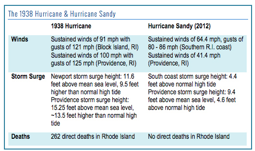
While Sandy caused significant damage, the 1938 hurricane eclipsed
the 2012 storm in wind speed, height of storm surge and overall strength.
Furthermore, coastal development has reclaimed much of the land area impacted by
the ’38 storm, so even more property, assets and infrastructure will be at risk
should a 100-year-storm hit Rhode Island directly. (CRMC)
The hope with Resilient
Rhody is that it doesn’t end up being a political tool strategically unveiled
before an election. Most of Rhode Island’s environment-related state reports,
guides and plans are celebrated, filed away and then ignored as the local
inequality chasm widens and the Ocean State’s natural world is chewed up.
From the outside — this
reporter did participate in one of the 10 “Resiliency Roundtables” held
statewide to help craft the plan — Resilient Rhody appears to be a hastened
attempt to address a serious issue: an overworked state employee given less
than a year and very limited funding to identify “projects, policies and
legislation, or funding and financing opportunities that the state can take to
better prepare for a changing climate.”
One climate-related issue
Rhode Island is already well focused on is the vulnerability of wastewater
treatment plants, as increasingly intense storms have damaged such facilities
and pump stations, which are typically located in low-lying areas.
Of the state’s 19 major
treatment facilities, seven are predicted to become predominantly inundated in
a catastrophic event, according to a Rhode Island
Department of Environmental Management study.
“Warren, to its credit, is
discussing a new location for its sewage treatment plant,” Fugate said. “That’s
what is needed — a change in thinking.”
The Rhode Island Department
of Health (DOH) is studying vector-borne diseases associated with a warming and
wetter local climate and educating the public about the growing problem.
Between 2016 and 2017, Rhode
Island saw a 22 percent increase in the number of cases of Lyme disease
reported by health-care providers to the DOH. Earlier this month, the Centers
for Disease Control and Prevention issued a report stating
that the number of cases of diseases that are transmitted by ticks, mosquitos
and other insects more than tripled between 2004 and 2016.
“We’re not doing enough yet
to address the impacts of climate change, but we have the information to make
the necessary moves,” Fugate said. “It takes leadership."
Resilience examples: Multi-stable
socio-ecological systems; smart growth; low-impact development; planning that
accounts for both acute events such as heavy rains, hurricanes and wildfires
that will become more frequent and intense as the climate changes and for
chronic events such as rising sea levels, worsening air quality and population
migration; regional wastewater treatment facilities.
R.I. efforts: PREP-RI online module series helps
municipal decision-makers make effective choices supporting resilience to the
impacts of climate change; Rapid
Property Assessment and Coastal Exposure (Rapid PACE) helps
local officials and property owners view areas exposed to coastal hazards;
lauded renewable-energy programs.


Subscribe to:
Posts (Atom)